You are here: Home > Network List > TA - USArray Transportable Network (new EarthScope stations) Stations List
> Station Z27A Tatum, NM, USA > Earthquake Result Viewer
Z27A Tatum, NM, USA - Earthquake Result Viewer
| Earthquake location: |
Tonga Islands |
| Earthquake latitude/longitude: |
-20.8/-173.3 |
| Earthquake time(UTC): |
2008/06/26 (178) 21:19:15 GMT |
| Earthquake Depth: |
38 km |
| Earthquake Magnitude: |
6.0 MB, 5.8 MS, 6.2 MW, 6.1 MW |
| Earthquake Catalog/Contributor: |
WHDF/NEIC |
|
| Network: |
TA USArray Transportable Network (new EarthScope stations) |
| Station: |
Z27A Tatum, NM, USA |
| Lat/Lon: |
33.31 N/103.21 W |
| Elevation: |
1197 m |
|
| Distance: |
85.8 deg |
| Az: |
52.151 deg |
| Baz: |
241.943 deg |
| Ray Param: |
0.044468336 |
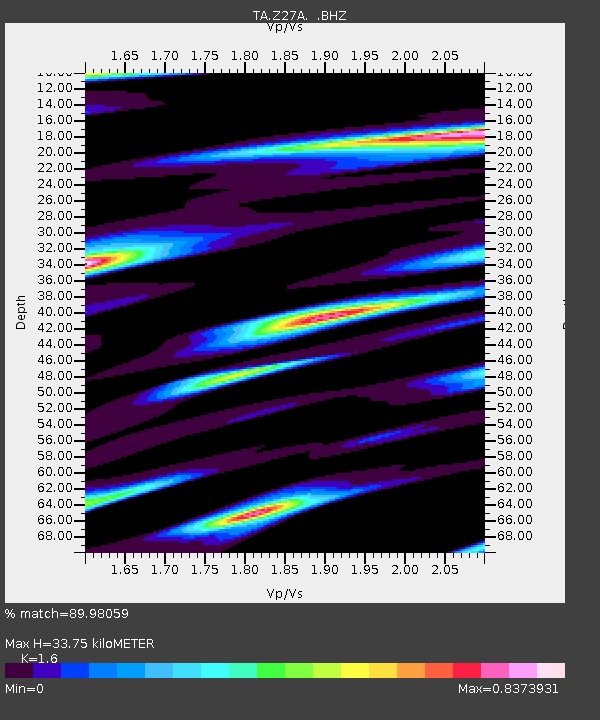
| Estimated Moho Depth: |
33.75 km |
| Estimated Crust Vp/Vs: |
1.60 |
| Assumed Crust Vp: |
6.129 km/s |
| Estimated Crust Vs: |
3.831 km/s |
| Estimated Crust Poisson's Ratio: |
0.18 |
|
| Radial Match: |
89.98059 % |
| Radial Bump: |
400 |
| Transverse Match: |
75.72656 % |
| Transverse Bump: |
400 |
| SOD ConfigId: |
2504 |
| Insert Time: |
2010-03-06 20:47:58.891 +0000 |
| GWidth: |
2.5 |
| Max Bumps: |
400 |
| Tol: |
0.001 |
|
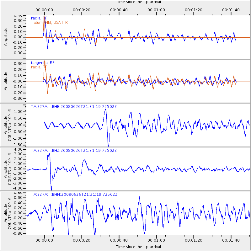
Signal To Noise
| Channel | StoN | STA | LTA |
| TA:Z27A: :BHZ:20080626T21:31:19.72502Z | 15.820321 | 2.0422808E-6 | 1.2909226E-7 |
| TA:Z27A: :BHN:20080626T21:31:19.72502Z | 3.536717 | 3.0799058E-7 | 8.7083755E-8 |
| TA:Z27A: :BHE:20080626T21:31:19.72502Z | 5.8043656 | 7.845632E-7 | 1.3516778E-7 |
| Arrivals |
| Ps | 3.4 SECOND |
| PpPs | 14 SECOND |
| PsPs/PpSs | 17 SECOND |


