You are here: Home > Network List > US - United States National Seismic Network Stations List
> Station LAO LASA Array, Montana, USA > Earthquake Result Viewer
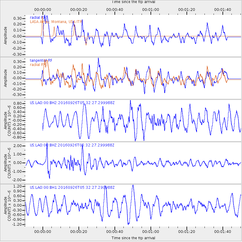
LAO LASA Array, Montana, USA - Earthquake Result Viewer
*The percent match for this event was below the threshold and hence no stack was calculated.
| Earthquake location: |
Ryukyu Islands, Japan |
| Earthquake latitude/longitude: |
27.5/128.6 |
| Earthquake time(UTC): |
2016/09/26 (270) 05:19:58 GMT |
| Earthquake Depth: |
40 km |
| Earthquake Magnitude: |
6.0 MB |
| Earthquake Catalog/Contributor: |
NEIC PDE/NEIC ALERT |
|
| Network: |
US United States National Seismic Network |
| Station: |
LAO LASA Array, Montana, USA |
| Lat/Lon: |
46.69 N/106.22 W |
| Elevation: |
902 m |
|
| Distance: |
91.1 deg |
| Az: |
34.23 deg |
| Baz: |
313.445 deg |
| Ray Param: |
$rayparam |
*The percent match for this event was below the threshold and hence was not used in the summary stack. |
|
| Radial Match: |
49.428825 % |
| Radial Bump: |
400 |
| Transverse Match: |
35.292385 % |
| Transverse Bump: |
400 |
| SOD ConfigId: |
1634031 |
| Insert Time: |
2016-10-10 05:23:17.611 +0000 |
| GWidth: |
2.5 |
| Max Bumps: |
400 |
| Tol: |
0.001 |
|
Signal To Noise
| Channel | StoN | STA | LTA |
| US:LAO:00:BHZ:20160926T05:32:27.299988Z | 5.3457255 | 8.938286E-7 | 1.6720436E-7 |
| US:LAO:00:BH1:20160926T05:32:27.299988Z | 0.7587054 | 4.0684574E-7 | 5.3623677E-7 |
| US:LAO:00:BH2:20160926T05:32:27.299988Z | 0.88873523 | 3.125522E-7 | 3.5168202E-7 |
| Arrivals |
| Ps | |
| PpPs | |
| PsPs/PpSs | |


