You are here: Home > Network List > TA - USArray Transportable Network (new EarthScope stations) Stations List
> Station Z27A Tatum, NM, USA > Earthquake Result Viewer
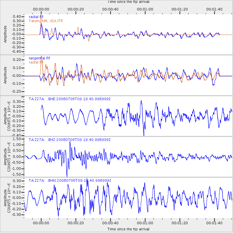
Z27A Tatum, NM, USA - Earthquake Result Viewer
*The percent match for this event was below the threshold and hence no stack was calculated.
| Earthquake location: |
Kuril Islands |
| Earthquake latitude/longitude: |
45.4/151.0 |
| Earthquake time(UTC): |
2008/07/06 (188) 09:08:20 GMT |
| Earthquake Depth: |
10 km |
| Earthquake Magnitude: |
5.8 MB, 5.4 MS, 5.7 MW, 5.7 MW |
| Earthquake Catalog/Contributor: |
WHDF/NEIC |
|
| Network: |
TA USArray Transportable Network (new EarthScope stations) |
| Station: |
Z27A Tatum, NM, USA |
| Lat/Lon: |
33.31 N/103.21 W |
| Elevation: |
1197 m |
|
| Distance: |
76.9 deg |
| Az: |
55.811 deg |
| Baz: |
315.882 deg |
| Ray Param: |
$rayparam |
*The percent match for this event was below the threshold and hence was not used in the summary stack. |
|
| Radial Match: |
59.208965 % |
| Radial Bump: |
400 |
| Transverse Match: |
44.922245 % |
| Transverse Bump: |
400 |
| SOD ConfigId: |
2504 |
| Insert Time: |
2010-03-06 20:48:14.642 +0000 |
| GWidth: |
2.5 |
| Max Bumps: |
400 |
| Tol: |
0.001 |
|
Signal To Noise
| Channel | StoN | STA | LTA |
| TA:Z27A: :BHZ:20080706T09:19:40.998999Z | 2.8755496 | 2.7508338E-7 | 9.5662884E-8 |
| TA:Z27A: :BHN:20080706T09:19:40.998999Z | 0.6789259 | 7.325377E-8 | 1.07896575E-7 |
| TA:Z27A: :BHE:20080706T09:19:40.998999Z | 1.073727 | 9.62875E-8 | 8.967596E-8 |
| Arrivals |
| Ps | |
| PpPs | |
| PsPs/PpSs | |


