You are here: Home > Network List > TA - USArray Transportable Network (new EarthScope stations) Stations List
> Station Z27A Tatum, NM, USA > Earthquake Result Viewer
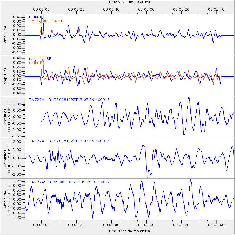
Z27A Tatum, NM, USA - Earthquake Result Viewer
*The percent match for this event was below the threshold and hence no stack was calculated.
| Earthquake location: |
Tonga Islands |
| Earthquake latitude/longitude: |
-18.4/-175.4 |
| Earthquake time(UTC): |
2008/10/22 (296) 12:55:57 GMT |
| Earthquake Depth: |
233 km |
| Earthquake Magnitude: |
5.9 MB, 6.4 MW, 6.3 MW |
| Earthquake Catalog/Contributor: |
WHDF/NEIC |
|
| Network: |
TA USArray Transportable Network (new EarthScope stations) |
| Station: |
Z27A Tatum, NM, USA |
| Lat/Lon: |
33.31 N/103.21 W |
| Elevation: |
1197 m |
|
| Distance: |
85.9 deg |
| Az: |
53.041 deg |
| Baz: |
244.962 deg |
| Ray Param: |
$rayparam |
*The percent match for this event was below the threshold and hence was not used in the summary stack. |
|
| Radial Match: |
72.38172 % |
| Radial Bump: |
400 |
| Transverse Match: |
50.235306 % |
| Transverse Bump: |
400 |
| SOD ConfigId: |
2560 |
| Insert Time: |
2010-03-06 20:48:25.132 +0000 |
| GWidth: |
2.5 |
| Max Bumps: |
400 |
| Tol: |
0.001 |
|
Signal To Noise
| Channel | StoN | STA | LTA |
| TA:Z27A: :BHZ:20081022T13:07:39.40001Z | 2.587506 | 6.30519E-7 | 2.4367827E-7 |
| TA:Z27A: :BHN:20081022T13:07:39.40001Z | 1.2581055 | 4.741317E-7 | 3.7686164E-7 |
| TA:Z27A: :BHE:20081022T13:07:39.40001Z | 1.87806 | 5.682487E-7 | 3.0257218E-7 |
| Arrivals |
| Ps | |
| PpPs | |
| PsPs/PpSs | |


