You are here: Home > Network List > TS - TERRAscope (Southern California Seismic Network) Stations List
> Station DGR Domenigoni Valley Reservior, California, USA > Earthquake Result Viewer
DGR Domenigoni Valley Reservior, California, USA - Earthquake Result Viewer
| Earthquake location: |
East Of Kuril Islands |
| Earthquake latitude/longitude: |
44.7/150.2 |
| Earthquake time(UTC): |
1994/08/18 (230) 04:42:59 GMT |
| Earthquake Depth: |
33 km |
| Earthquake Magnitude: |
6.1 MB, 6.5 MS, 6.6 UNKNOWN, 6.5 MW |
| Earthquake Catalog/Contributor: |
WHDF/NEIC |
|
| Network: |
TS TERRAscope (Southern California Seismic Network) |
| Station: |
DGR Domenigoni Valley Reservior, California, USA |
| Lat/Lon: |
33.65 N/117.01 W |
| Elevation: |
700 m |
|
| Distance: |
69.1 deg |
| Az: |
63.123 deg |
| Baz: |
310.275 deg |
| Ray Param: |
0.05583841 |
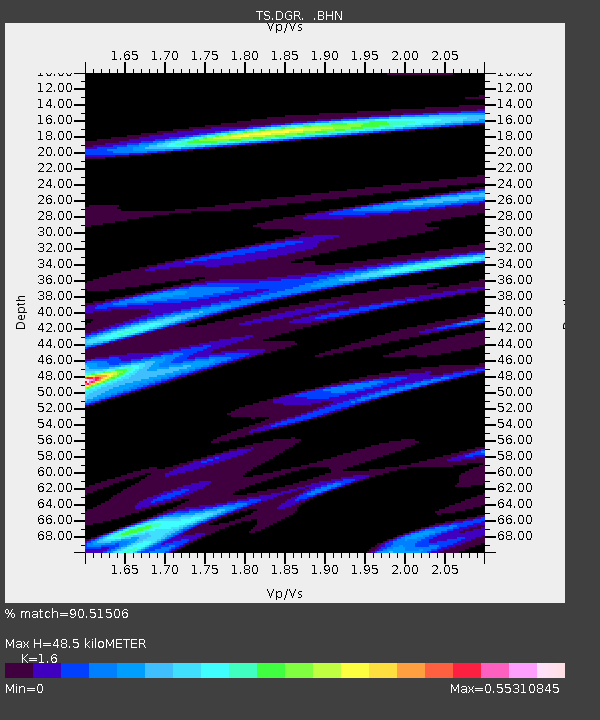
| Estimated Moho Depth: |
48.5 km |
| Estimated Crust Vp/Vs: |
1.60 |
| Assumed Crust Vp: |
6.264 km/s |
| Estimated Crust Vs: |
3.915 km/s |
| Estimated Crust Poisson's Ratio: |
0.18 |
|
| Radial Match: |
90.51506 % |
| Radial Bump: |
332 |
| Transverse Match: |
75.30461 % |
| Transverse Bump: |
400 |
| SOD ConfigId: |
17000 |
| Insert Time: |
2010-02-26 14:07:40.908 +0000 |
| GWidth: |
2.5 |
| Max Bumps: |
400 |
| Tol: |
0.001 |
|

Signal To Noise
| Channel | StoN | STA | LTA |
| TS:DGR: :BHN:19940818T04:53:31.303003Z | 1.6677858 | 2.40826E-7 | 1.4439865E-7 |
| TS:DGR: :BHE:19940818T04:53:31.303003Z | 1.2989156 | 2.1225232E-7 | 1.6340732E-7 |
| TS:DGR: :BHZ:19940818T04:53:31.303003Z | 3.1839943 | 3.4718633E-7 | 1.0904113E-7 |
| Arrivals |
| Ps | 4.8 SECOND |
| PpPs | 19 SECOND |
| PsPs/PpSs | 24 SECOND |


