You are here: Home > Network List > TA - USArray Transportable Network (new EarthScope stations) Stations List
> Station Z27A Tatum, NM, USA > Earthquake Result Viewer
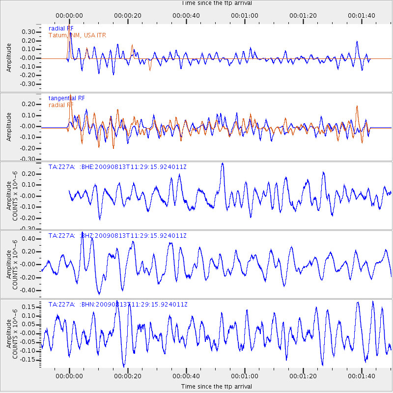
Z27A Tatum, NM, USA - Earthquake Result Viewer
*The percent match for this event was below the threshold and hence no stack was calculated.
| Earthquake location: |
Tonga Islands |
| Earthquake latitude/longitude: |
-21.7/-174.6 |
| Earthquake time(UTC): |
2009/08/13 (225) 11:17:01 GMT |
| Earthquake Depth: |
10 km |
| Earthquake Magnitude: |
5.6 MW, 5.3 MB |
| Earthquake Catalog/Contributor: |
WHDF/NEIC |
|
| Network: |
TA USArray Transportable Network (new EarthScope stations) |
| Station: |
Z27A Tatum, NM, USA |
| Lat/Lon: |
33.31 N/103.21 W |
| Elevation: |
1197 m |
|
| Distance: |
87.2 deg |
| Az: |
52.591 deg |
| Baz: |
241.935 deg |
| Ray Param: |
$rayparam |
*The percent match for this event was below the threshold and hence was not used in the summary stack. |
|
| Radial Match: |
72.98727 % |
| Radial Bump: |
400 |
| Transverse Match: |
54.44581 % |
| Transverse Bump: |
400 |
| SOD ConfigId: |
2622 |
| Insert Time: |
2010-03-06 20:48:28.952 +0000 |
| GWidth: |
2.5 |
| Max Bumps: |
400 |
| Tol: |
0.001 |
|
Signal To Noise
| Channel | StoN | STA | LTA |
| TA:Z27A: :BHZ:20090813T11:29:15.924011Z | 3.5342846 | 2.0723488E-7 | 5.8635592E-8 |
| TA:Z27A: :BHN:20090813T11:29:15.924011Z | 0.8255833 | 5.9579516E-8 | 7.216658E-8 |
| TA:Z27A: :BHE:20090813T11:29:15.924011Z | 1.0673922 | 6.579254E-8 | 6.163858E-8 |
| Arrivals |
| Ps | |
| PpPs | |
| PsPs/PpSs | |


