You are here: Home > Network List > TA - USArray Transportable Network (new EarthScope stations) Stations List
> Station Z27A Tatum, NM, USA > Earthquake Result Viewer
Z27A Tatum, NM, USA - Earthquake Result Viewer
*The percent match for this event was below the threshold and hence no stack was calculated.
| Earthquake location: |
Costa Rica |
| Earthquake latitude/longitude: |
8.5/-83.2 |
| Earthquake time(UTC): |
2009/03/11 (070) 21:03:58 GMT |
| Earthquake Depth: |
17 km |
| Earthquake Magnitude: |
5.7 MB, 5.6 MS, 5.9 MW, 5.8 MW |
| Earthquake Catalog/Contributor: |
WHDF/NEIC |
|
| Network: |
TA USArray Transportable Network (new EarthScope stations) |
| Station: |
Z27A Tatum, NM, USA |
| Lat/Lon: |
33.31 N/103.21 W |
| Elevation: |
1197 m |
|
| Distance: |
30.9 deg |
| Az: |
326.034 deg |
| Baz: |
138.7 deg |
| Ray Param: |
$rayparam |
*The percent match for this event was below the threshold and hence was not used in the summary stack. |
|
| Radial Match: |
75.932755 % |
| Radial Bump: |
400 |
| Transverse Match: |
58.590595 % |
| Transverse Bump: |
400 |
| SOD ConfigId: |
2658 |
| Insert Time: |
2010-03-06 20:48:55.548 +0000 |
| GWidth: |
2.5 |
| Max Bumps: |
400 |
| Tol: |
0.001 |
|
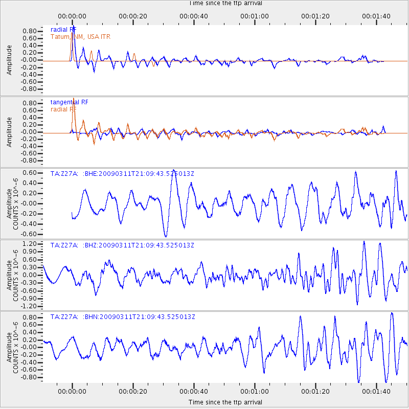
Signal To Noise
| Channel | StoN | STA | LTA |
| TA:Z27A: :BHZ:20090311T21:09:43.525013Z | 0.69287086 | 2.1503374E-7 | 3.1035182E-7 |
| TA:Z27A: :BHN:20090311T21:09:43.525013Z | 1.6476631 | 2.179837E-7 | 1.3229871E-7 |
| TA:Z27A: :BHE:20090311T21:09:43.525013Z | 2.7650182 | 4.5363726E-7 | 1.6406304E-7 |
| Arrivals |
| Ps | |
| PpPs | |
| PsPs/PpSs | |


