You are here: Home > Network List > TA - USArray Transportable Network (new EarthScope stations) Stations List
> Station Z27A Tatum, NM, USA > Earthquake Result Viewer
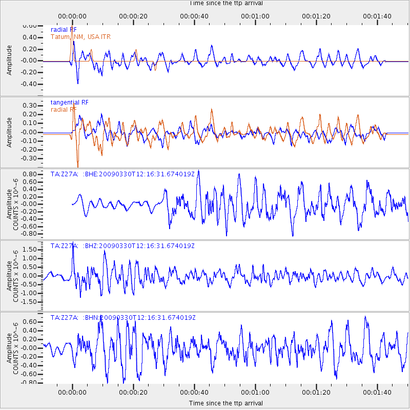
Z27A Tatum, NM, USA - Earthquake Result Viewer
*The percent match for this event was below the threshold and hence no stack was calculated.
| Earthquake location: |
Andreanof Islands, Aleutian Is. |
| Earthquake latitude/longitude: |
51.5/-178.3 |
| Earthquake time(UTC): |
2009/03/30 (089) 12:07:28 GMT |
| Earthquake Depth: |
31 km |
| Earthquake Magnitude: |
6.0 MB, 5.5 MS, 5.7 MW, 5.7 MW |
| Earthquake Catalog/Contributor: |
WHDF/NEIC |
|
| Network: |
TA USArray Transportable Network (new EarthScope stations) |
| Station: |
Z27A Tatum, NM, USA |
| Lat/Lon: |
33.31 N/103.21 W |
| Elevation: |
1197 m |
|
| Distance: |
55.8 deg |
| Az: |
77.951 deg |
| Baz: |
313.157 deg |
| Ray Param: |
$rayparam |
*The percent match for this event was below the threshold and hence was not used in the summary stack. |
|
| Radial Match: |
68.92811 % |
| Radial Bump: |
400 |
| Transverse Match: |
50.66925 % |
| Transverse Bump: |
387 |
| SOD ConfigId: |
2658 |
| Insert Time: |
2010-03-06 20:49:06.612 +0000 |
| GWidth: |
2.5 |
| Max Bumps: |
400 |
| Tol: |
0.001 |
|
Signal To Noise
| Channel | StoN | STA | LTA |
| TA:Z27A: :BHZ:20090330T12:16:31.674019Z | 6.7062473 | 6.151342E-7 | 9.1725546E-8 |
| TA:Z27A: :BHN:20090330T12:16:31.674019Z | 1.5262151 | 1.9290307E-7 | 1.263931E-7 |
| TA:Z27A: :BHE:20090330T12:16:31.674019Z | 2.6894646 | 2.8951416E-7 | 1.0764751E-7 |
| Arrivals |
| Ps | |
| PpPs | |
| PsPs/PpSs | |


