You are here: Home > Network List > TS - TERRAscope (Southern California Seismic Network) Stations List
> Station DGR Domenigoni Valley Reservior, California, USA > Earthquake Result Viewer
DGR Domenigoni Valley Reservior, California, USA - Earthquake Result Viewer
| Earthquake location: |
Kuril Islands |
| Earthquake latitude/longitude: |
44.7/149.1 |
| Earthquake time(UTC): |
1994/08/20 (232) 04:38:51 GMT |
| Earthquake Depth: |
33 km |
| Earthquake Magnitude: |
6.1 MB, 6.0 MS, 5.7 UNKNOWN, 6.3 MW |
| Earthquake Catalog/Contributor: |
WHDF/NEIC |
|
| Network: |
TS TERRAscope (Southern California Seismic Network) |
| Station: |
DGR Domenigoni Valley Reservior, California, USA |
| Lat/Lon: |
33.65 N/117.01 W |
| Elevation: |
700 m |
|
| Distance: |
69.7 deg |
| Az: |
62.526 deg |
| Baz: |
310.636 deg |
| Ray Param: |
0.05540352 |
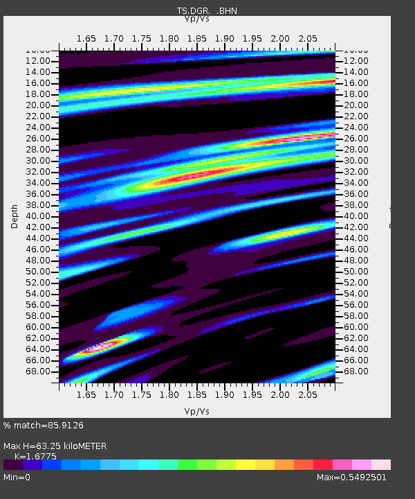
| Estimated Moho Depth: |
63.25 km |
| Estimated Crust Vp/Vs: |
1.68 |
| Assumed Crust Vp: |
6.264 km/s |
| Estimated Crust Vs: |
3.734 km/s |
| Estimated Crust Poisson's Ratio: |
0.22 |
|
| Radial Match: |
85.9126 % |
| Radial Bump: |
400 |
| Transverse Match: |
66.60955 % |
| Transverse Bump: |
400 |
| SOD ConfigId: |
17000 |
| Insert Time: |
2010-02-26 14:07:43.394 +0000 |
| GWidth: |
2.5 |
| Max Bumps: |
400 |
| Tol: |
0.001 |
|
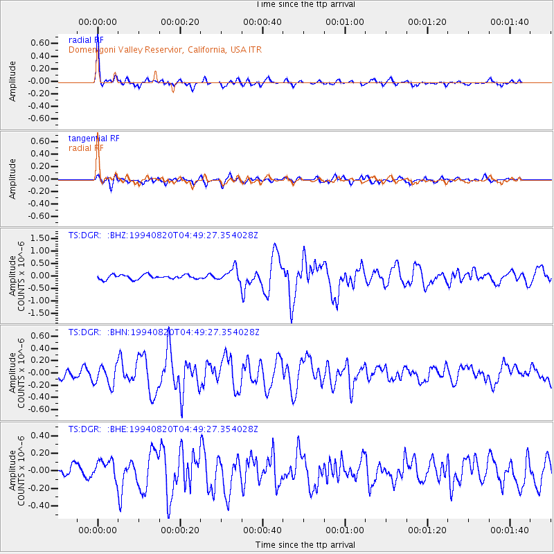
Signal To Noise
| Channel | StoN | STA | LTA |
| TS:DGR: :BHN:19940820T04:49:27.354028Z | 1.679866 | 1.6159665E-7 | 9.619615E-8 |
| TS:DGR: :BHE:19940820T04:49:27.354028Z | 1.0274371 | 1.14789756E-7 | 1.1172437E-7 |
| TS:DGR: :BHZ:19940820T04:49:27.354028Z | 3.1246374 | 2.7610236E-7 | 8.8363E-8 |
| Arrivals |
| Ps | 7.1 SECOND |
| PpPs | 26 SECOND |
| PsPs/PpSs | 33 SECOND |


