You are here: Home > Network List > TA - USArray Transportable Network (new EarthScope stations) Stations List
> Station Z27A Tatum, NM, USA > Earthquake Result Viewer
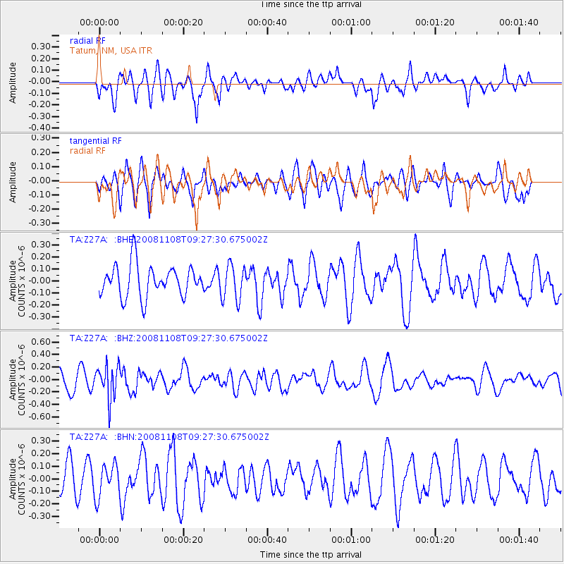
Z27A Tatum, NM, USA - Earthquake Result Viewer
*The percent match for this event was below the threshold and hence no stack was calculated.
| Earthquake location: |
Tonga Islands |
| Earthquake latitude/longitude: |
-15.2/-174.2 |
| Earthquake time(UTC): |
2008/11/08 (313) 09:15:51 GMT |
| Earthquake Depth: |
140 km |
| Earthquake Magnitude: |
5.5 MW, 5.3 MB |
| Earthquake Catalog/Contributor: |
WHDF/NEIC |
|
| Network: |
TA USArray Transportable Network (new EarthScope stations) |
| Station: |
Z27A Tatum, NM, USA |
| Lat/Lon: |
33.31 N/103.21 W |
| Elevation: |
1197 m |
|
| Distance: |
83.1 deg |
| Az: |
52.896 deg |
| Baz: |
246.85 deg |
| Ray Param: |
$rayparam |
*The percent match for this event was below the threshold and hence was not used in the summary stack. |
|
| Radial Match: |
59.336185 % |
| Radial Bump: |
400 |
| Transverse Match: |
30.165531 % |
| Transverse Bump: |
394 |
| SOD ConfigId: |
2658 |
| Insert Time: |
2010-03-06 20:49:09.204 +0000 |
| GWidth: |
2.5 |
| Max Bumps: |
400 |
| Tol: |
0.001 |
|
Signal To Noise
| Channel | StoN | STA | LTA |
| TA:Z27A: :BHZ:20081108T09:27:30.675002Z | 2.1911287 | 2.702767E-7 | 1.2335045E-7 |
| TA:Z27A: :BHN:20081108T09:27:30.675002Z | 1.0549457 | 1.3054708E-7 | 1.2374768E-7 |
| TA:Z27A: :BHE:20081108T09:27:30.675002Z | 1.1154776 | 1.4697744E-7 | 1.317619E-7 |
| Arrivals |
| Ps | |
| PpPs | |
| PsPs/PpSs | |


