You are here: Home > Network List > TA - USArray Transportable Network (new EarthScope stations) Stations List
> Station Z27A Tatum, NM, USA > Earthquake Result Viewer
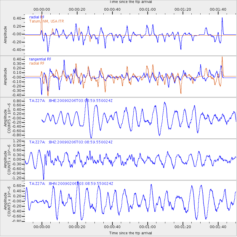
Z27A Tatum, NM, USA - Earthquake Result Viewer
*The percent match for this event was below the threshold and hence no stack was calculated.
| Earthquake location: |
Near Coast Of Northern Chile |
| Earthquake latitude/longitude: |
-28.0/-71.1 |
| Earthquake time(UTC): |
2009/02/06 (037) 02:58:35 GMT |
| Earthquake Depth: |
52 km |
| Earthquake Magnitude: |
5.5 MB |
| Earthquake Catalog/Contributor: |
WHDF/NEIC |
|
| Network: |
TA USArray Transportable Network (new EarthScope stations) |
| Station: |
Z27A Tatum, NM, USA |
| Lat/Lon: |
33.31 N/103.21 W |
| Elevation: |
1197 m |
|
| Distance: |
68.2 deg |
| Az: |
331.346 deg |
| Baz: |
149.573 deg |
| Ray Param: |
$rayparam |
*The percent match for this event was below the threshold and hence was not used in the summary stack. |
|
| Radial Match: |
44.5537 % |
| Radial Bump: |
400 |
| Transverse Match: |
63.46659 % |
| Transverse Bump: |
400 |
| SOD ConfigId: |
2658 |
| Insert Time: |
2010-03-06 20:49:15.199 +0000 |
| GWidth: |
2.5 |
| Max Bumps: |
400 |
| Tol: |
0.001 |
|
Signal To Noise
| Channel | StoN | STA | LTA |
| TA:Z27A: :BHZ:20090206T03:08:59.550024Z | 2.2265635 | 5.107763E-7 | 2.294012E-7 |
| TA:Z27A: :BHN:20090206T03:08:59.550024Z | 0.28952175 | 9.98692E-8 | 3.449454E-7 |
| TA:Z27A: :BHE:20090206T03:08:59.550024Z | 1.932532 | 4.1266347E-7 | 2.1353513E-7 |
| Arrivals |
| Ps | |
| PpPs | |
| PsPs/PpSs | |


