You are here: Home > Network List > TA - USArray Transportable Network (new EarthScope stations) Stations List
> Station Z27A Tatum, NM, USA > Earthquake Result Viewer
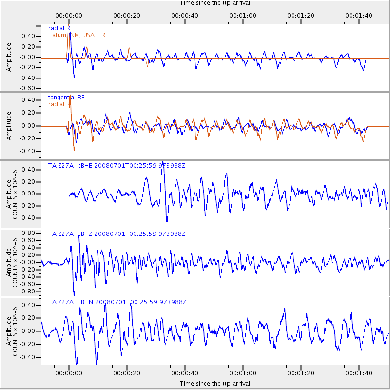
Z27A Tatum, NM, USA - Earthquake Result Viewer
*The percent match for this event was below the threshold and hence no stack was calculated.
| Earthquake location: |
Central Peru |
| Earthquake latitude/longitude: |
-10.4/-75.5 |
| Earthquake time(UTC): |
2008/07/01 (183) 00:17:33 GMT |
| Earthquake Depth: |
33 km |
| Earthquake Magnitude: |
5.5 MW, 5.0 MS, 5.4 MB, 5.3 ML |
| Earthquake Catalog/Contributor: |
WHDF/NEIC |
|
| Network: |
TA USArray Transportable Network (new EarthScope stations) |
| Station: |
Z27A Tatum, NM, USA |
| Lat/Lon: |
33.31 N/103.21 W |
| Elevation: |
1197 m |
|
| Distance: |
50.8 deg |
| Az: |
329.859 deg |
| Baz: |
143.843 deg |
| Ray Param: |
$rayparam |
*The percent match for this event was below the threshold and hence was not used in the summary stack. |
|
| Radial Match: |
62.17296 % |
| Radial Bump: |
386 |
| Transverse Match: |
60.37273 % |
| Transverse Bump: |
374 |
| SOD ConfigId: |
2504 |
| Insert Time: |
2010-03-06 20:49:31.096 +0000 |
| GWidth: |
2.5 |
| Max Bumps: |
400 |
| Tol: |
0.001 |
|
Signal To Noise
| Channel | StoN | STA | LTA |
| TA:Z27A: :BHZ:20080701T00:25:59.973988Z | 5.2917557 | 4.1007917E-7 | 7.749397E-8 |
| TA:Z27A: :BHN:20080701T00:25:59.973988Z | 3.7861786 | 2.3875344E-7 | 6.305921E-8 |
| TA:Z27A: :BHE:20080701T00:25:59.973988Z | 4.4880686 | 2.7268993E-7 | 6.075886E-8 |
| Arrivals |
| Ps | |
| PpPs | |
| PsPs/PpSs | |


