You are here: Home > Network List > JP - Japan Meteorological Agency Seismic Network Stations List
> Station JSD Sado > Earthquake Result Viewer
JSD Sado - Earthquake Result Viewer
| Earthquake location: |
Sumbawa Region, Indonesia |
| Earthquake latitude/longitude: |
-8.4/116.5 |
| Earthquake time(UTC): |
2019/03/17 (076) 07:07:27 GMT |
| Earthquake Depth: |
24 km |
| Earthquake Magnitude: |
5.5 Mww |
| Earthquake Catalog/Contributor: |
NEIC PDE/us |
|
| Network: |
JP Japan Meteorological Agency Seismic Network |
| Station: |
JSD Sado |
| Lat/Lon: |
38.04 N/138.26 E |
| Elevation: |
146 m |
|
| Distance: |
50.5 deg |
| Az: |
22.278 deg |
| Baz: |
208.361 deg |
| Ray Param: |
0.067994505 |
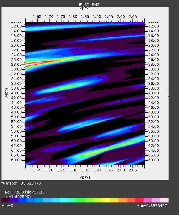
| Estimated Moho Depth: |
28.0 km |
| Estimated Crust Vp/Vs: |
1.60 |
| Assumed Crust Vp: |
6.183 km/s |
| Estimated Crust Vs: |
3.858 km/s |
| Estimated Crust Poisson's Ratio: |
0.18 |
|
| Radial Match: |
83.523476 % |
| Radial Bump: |
400 |
| Transverse Match: |
62.753536 % |
| Transverse Bump: |
400 |
| SOD ConfigId: |
13570011 |
| Insert Time: |
2019-05-02 18:24:00.690 +0000 |
| GWidth: |
2.5 |
| Max Bumps: |
400 |
| Tol: |
0.001 |
|

Signal To Noise
| Channel | StoN | STA | LTA |
| JP:JSD: :BHZ:20190317T07:15:52.849987Z | 5.0168376 | 7.377938E-7 | 1.4706352E-7 |
| JP:JSD: :BHN:20190317T07:15:52.849987Z | 3.0292604 | 1.0103547E-6 | 3.3353183E-7 |
| JP:JSD: :BHE:20190317T07:15:52.849987Z | 2.1008584 | 3.8058056E-7 | 1.8115479E-7 |
| Arrivals |
| Ps | 2.9 SECOND |
| PpPs | 11 SECOND |
| PsPs/PpSs | 14 SECOND |


