You are here: Home > Network List > TA - USArray Transportable Network (new EarthScope stations) Stations List
> Station Y27A Causey, NM, USA > Earthquake Result Viewer
Y27A Causey, NM, USA - Earthquake Result Viewer
| Earthquake location: |
Fiji Islands Region |
| Earthquake latitude/longitude: |
-17.3/-177.3 |
| Earthquake time(UTC): |
2008/07/19 (201) 22:39:52 GMT |
| Earthquake Depth: |
391 km |
| Earthquake Magnitude: |
5.9 MB, 6.4 MW, 6.4 MW |
| Earthquake Catalog/Contributor: |
WHDF/NEIC |
|
| Network: |
TA USArray Transportable Network (new EarthScope stations) |
| Station: |
Y27A Causey, NM, USA |
| Lat/Lon: |
33.88 N/103.16 W |
| Elevation: |
1253 m |
|
| Distance: |
87.0 deg |
| Az: |
53.262 deg |
| Baz: |
246.94 deg |
| Ray Param: |
0.042641636 |
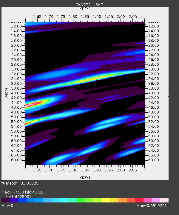
| Estimated Moho Depth: |
45.0 km |
| Estimated Crust Vp/Vs: |
1.60 |
| Assumed Crust Vp: |
6.129 km/s |
| Estimated Crust Vs: |
3.825 km/s |
| Estimated Crust Poisson's Ratio: |
0.18 |
|
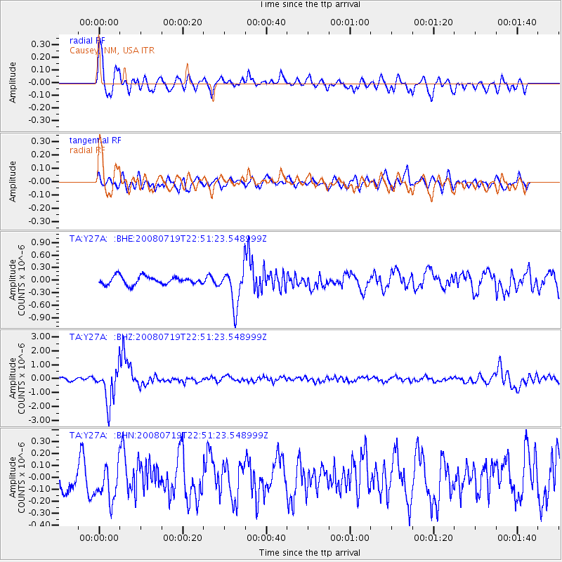
| Radial Match: |
81.33035 % |
| Radial Bump: |
400 |
| Transverse Match: |
62.503 % |
| Transverse Bump: |
400 |
| SOD ConfigId: |
2504 |
| Insert Time: |
2010-03-06 20:49:37.903 +0000 |
| GWidth: |
2.5 |
| Max Bumps: |
400 |
| Tol: |
0.001 |
|
Signal To Noise
| Channel | StoN | STA | LTA |
| TA:Y27A: :BHZ:20080719T22:51:23.548999Z | 9.578564 | 1.3144065E-6 | 1.3722376E-7 |
| TA:Y27A: :BHN:20080719T22:51:23.548999Z | 1.236536 | 1.525023E-7 | 1.2333025E-7 |
| TA:Y27A: :BHE:20080719T22:51:23.548999Z | 4.912574 | 4.677938E-7 | 9.522377E-8 |
| Arrivals |
| Ps | 4.5 SECOND |
| PpPs | 19 SECOND |
| PsPs/PpSs | 23 SECOND |


