You are here: Home > Network List > TA - USArray Transportable Network (new EarthScope stations) Stations List
> Station Y27A Causey, NM, USA > Earthquake Result Viewer
Y27A Causey, NM, USA - Earthquake Result Viewer
| Earthquake location: |
Tonga Islands |
| Earthquake latitude/longitude: |
-21.9/-173.8 |
| Earthquake time(UTC): |
2008/10/19 (293) 05:10:33 GMT |
| Earthquake Depth: |
29 km |
| Earthquake Magnitude: |
6.8 MB, 7.0 MS, 6.9 MW, 6.9 MW |
| Earthquake Catalog/Contributor: |
WHDF/NEIC |
|
| Network: |
TA USArray Transportable Network (new EarthScope stations) |
| Station: |
Y27A Causey, NM, USA |
| Lat/Lon: |
33.88 N/103.16 W |
| Elevation: |
1253 m |
|
| Distance: |
87.1 deg |
| Az: |
51.807 deg |
| Baz: |
241.356 deg |
| Ray Param: |
0.043530066 |
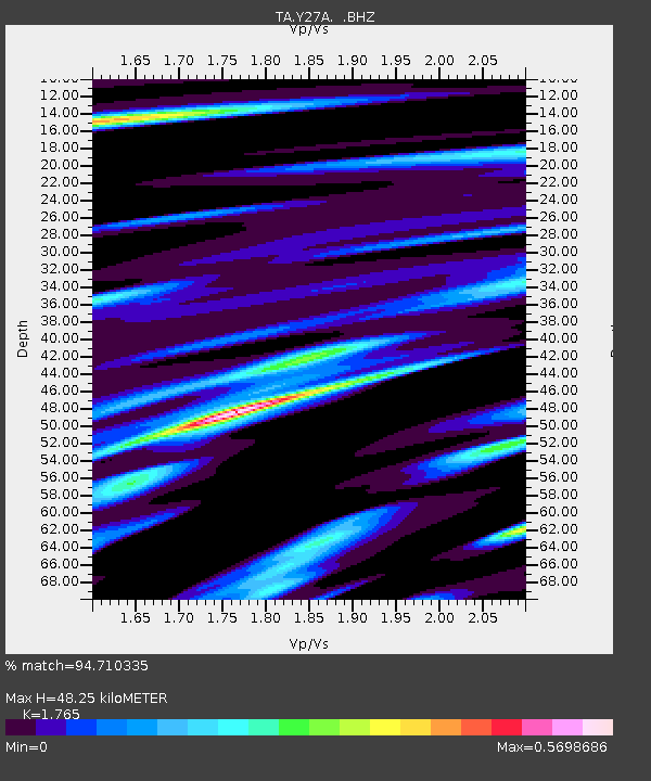
| Estimated Moho Depth: |
48.25 km |
| Estimated Crust Vp/Vs: |
1.76 |
| Assumed Crust Vp: |
6.129 km/s |
| Estimated Crust Vs: |
3.472 km/s |
| Estimated Crust Poisson's Ratio: |
0.26 |
|
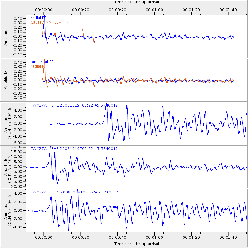
| Radial Match: |
94.710335 % |
| Radial Bump: |
311 |
| Transverse Match: |
90.61889 % |
| Transverse Bump: |
390 |
| SOD ConfigId: |
2556 |
| Insert Time: |
2010-03-06 20:49:52.658 +0000 |
| GWidth: |
2.5 |
| Max Bumps: |
400 |
| Tol: |
0.001 |
|
Signal To Noise
| Channel | StoN | STA | LTA |
| TA:Y27A: :BHZ:20081019T05:22:45.574001Z | 60.81383 | 8.08984E-6 | 1.3302632E-7 |
| TA:Y27A: :BHN:20081019T05:22:45.574001Z | 5.946972 | 1.5009919E-6 | 2.52396E-7 |
| TA:Y27A: :BHE:20081019T05:22:45.574001Z | 18.444164 | 2.5907855E-6 | 1.404664E-7 |
| Arrivals |
| Ps | 6.1 SECOND |
| PpPs | 21 SECOND |
| PsPs/PpSs | 27 SECOND |


