You are here: Home > Network List > TS - TERRAscope (Southern California Seismic Network) Stations List
> Station DGR Domenigoni Valley Reservior, California, USA > Earthquake Result Viewer
DGR Domenigoni Valley Reservior, California, USA - Earthquake Result Viewer
| Earthquake location: |
Hokkaido, Japan Region |
| Earthquake latitude/longitude: |
43.7/146.0 |
| Earthquake time(UTC): |
1994/08/31 (243) 09:07:26 GMT |
| Earthquake Depth: |
80 km |
| Earthquake Magnitude: |
5.9 MB, 6.2 UNKNOWN, 6.2 MW |
| Earthquake Catalog/Contributor: |
WHDF/NEIC |
|
| Network: |
TS TERRAscope (Southern California Seismic Network) |
| Station: |
DGR Domenigoni Valley Reservior, California, USA |
| Lat/Lon: |
33.65 N/117.01 W |
| Elevation: |
700 m |
|
| Distance: |
72.2 deg |
| Az: |
60.416 deg |
| Baz: |
310.874 deg |
| Ray Param: |
0.05364441 |
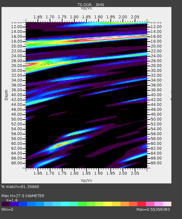
| Estimated Moho Depth: |
27.5 km |
| Estimated Crust Vp/Vs: |
1.60 |
| Assumed Crust Vp: |
6.264 km/s |
| Estimated Crust Vs: |
3.915 km/s |
| Estimated Crust Poisson's Ratio: |
0.18 |
|
| Radial Match: |
81.35668 % |
| Radial Bump: |
400 |
| Transverse Match: |
63.413986 % |
| Transverse Bump: |
400 |
| SOD ConfigId: |
17000 |
| Insert Time: |
2010-02-26 14:07:49.121 +0000 |
| GWidth: |
2.5 |
| Max Bumps: |
400 |
| Tol: |
0.001 |
|

Signal To Noise
| Channel | StoN | STA | LTA |
| TS:DGR: :BHN:19940831T09:18:11.554004Z | 2.0936904 | 1.8654306E-7 | 8.909773E-8 |
| TS:DGR: :BHE:19940831T09:18:11.554004Z | 2.9113572 | 2.1325917E-7 | 7.3250774E-8 |
| TS:DGR: :BHZ:19940831T09:18:11.554004Z | 3.5033603 | 5.19647E-7 | 1.4832817E-7 |
| Arrivals |
| Ps | 2.7 SECOND |
| PpPs | 11 SECOND |
| PsPs/PpSs | 14 SECOND |


