You are here: Home > Network List > TA - USArray Transportable Network (new EarthScope stations) Stations List
> Station Y27A Causey, NM, USA > Earthquake Result Viewer
Y27A Causey, NM, USA - Earthquake Result Viewer
| Earthquake location: |
Panama-Costa Rica Border Region |
| Earthquake latitude/longitude: |
8.3/-83.0 |
| Earthquake time(UTC): |
2008/11/19 (324) 06:11:20 GMT |
| Earthquake Depth: |
32 km |
| Earthquake Magnitude: |
5.9 MB, 5.9 MS, 6.2 MW, 6.1 MW |
| Earthquake Catalog/Contributor: |
WHDF/NEIC |
|
| Network: |
TA USArray Transportable Network (new EarthScope stations) |
| Station: |
Y27A Causey, NM, USA |
| Lat/Lon: |
33.88 N/103.16 W |
| Elevation: |
1253 m |
|
| Distance: |
31.6 deg |
| Az: |
326.73 deg |
| Baz: |
139.256 deg |
| Ray Param: |
0.078973696 |
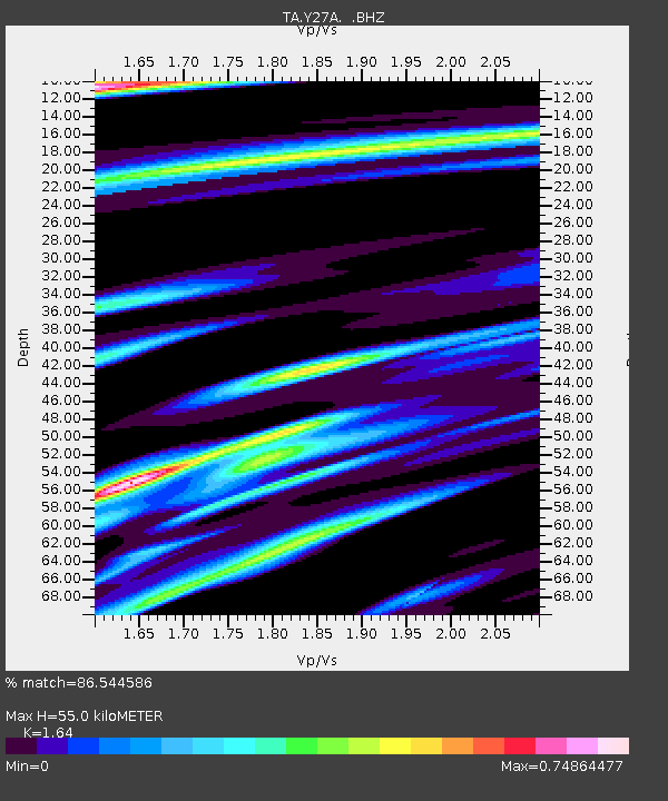
| Estimated Moho Depth: |
55.0 km |
| Estimated Crust Vp/Vs: |
1.64 |
| Assumed Crust Vp: |
6.129 km/s |
| Estimated Crust Vs: |
3.737 km/s |
| Estimated Crust Poisson's Ratio: |
0.20 |
|
| Radial Match: |
86.544586 % |
| Radial Bump: |
290 |
| Transverse Match: |
63.718735 % |
| Transverse Bump: |
389 |
| SOD ConfigId: |
2658 |
| Insert Time: |
2010-03-06 20:50:01.147 +0000 |
| GWidth: |
2.5 |
| Max Bumps: |
400 |
| Tol: |
0.001 |
|
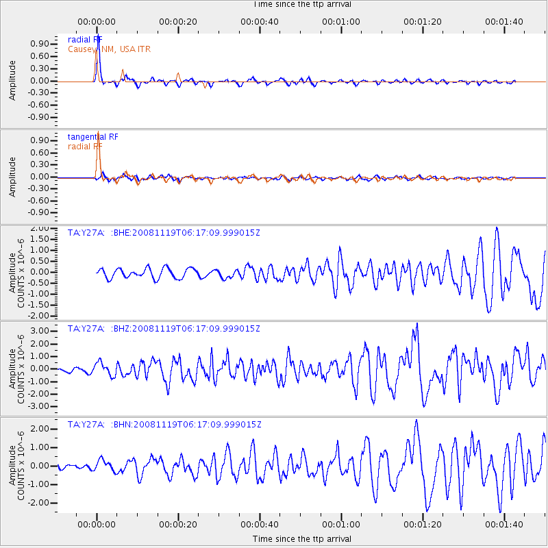
Signal To Noise
| Channel | StoN | STA | LTA |
| TA:Y27A: :BHZ:20081119T06:17:09.999015Z | 3.9327028 | 5.2068515E-7 | 1.3239881E-7 |
| TA:Y27A: :BHN:20081119T06:17:09.999015Z | 2.1071663 | 3.0231354E-7 | 1.4346922E-7 |
| TA:Y27A: :BHE:20081119T06:17:09.999015Z | 0.86182725 | 1.8927143E-7 | 2.1961645E-7 |
| Arrivals |
| Ps | 6.2 SECOND |
| PpPs | 22 SECOND |
| PsPs/PpSs | 28 SECOND |


