You are here: Home > Network List > TA - USArray Transportable Network (new EarthScope stations) Stations List
> Station Y27A Causey, NM, USA > Earthquake Result Viewer
Y27A Causey, NM, USA - Earthquake Result Viewer
| Earthquake location: |
Southeast Of Honshu, Japan |
| Earthquake latitude/longitude: |
32.8/140.4 |
| Earthquake time(UTC): |
2009/08/12 (224) 22:48:51 GMT |
| Earthquake Depth: |
53 km |
| Earthquake Magnitude: |
6.2 MB, 6.6 MW, 6.6 MW |
| Earthquake Catalog/Contributor: |
WHDF/NEIC |
|
| Network: |
TA USArray Transportable Network (new EarthScope stations) |
| Station: |
Y27A Causey, NM, USA |
| Lat/Lon: |
33.88 N/103.16 W |
| Elevation: |
1253 m |
|
| Distance: |
90.7 deg |
| Az: |
48.153 deg |
| Baz: |
311.062 deg |
| Ray Param: |
0.041644804 |
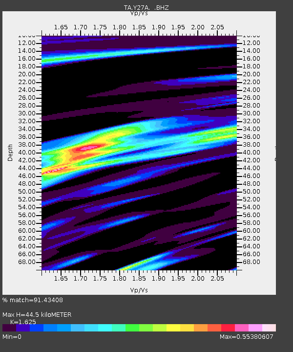
| Estimated Moho Depth: |
44.5 km |
| Estimated Crust Vp/Vs: |
1.62 |
| Assumed Crust Vp: |
6.129 km/s |
| Estimated Crust Vs: |
3.772 km/s |
| Estimated Crust Poisson's Ratio: |
0.20 |
|
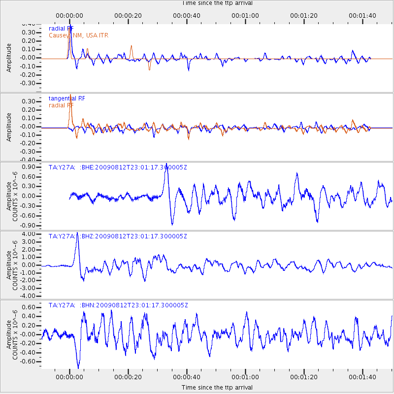
| Radial Match: |
91.43408 % |
| Radial Bump: |
269 |
| Transverse Match: |
79.14084 % |
| Transverse Bump: |
400 |
| SOD ConfigId: |
2622 |
| Insert Time: |
2010-03-06 20:50:04.943 +0000 |
| GWidth: |
2.5 |
| Max Bumps: |
400 |
| Tol: |
0.001 |
|
Signal To Noise
| Channel | StoN | STA | LTA |
| TA:Y27A: :BHZ:20090812T23:01:17.300005Z | 24.708849 | 1.7421596E-6 | 7.050752E-8 |
| TA:Y27A: :BHN:20090812T23:01:17.300005Z | 5.484409 | 3.318296E-7 | 6.050417E-8 |
| TA:Y27A: :BHE:20090812T23:01:17.300005Z | 6.621404 | 4.4884914E-7 | 6.77876E-8 |
| Arrivals |
| Ps | 4.6 SECOND |
| PpPs | 19 SECOND |
| PsPs/PpSs | 23 SECOND |


