You are here: Home > Network List > TA - USArray Transportable Network (new EarthScope stations) Stations List
> Station Y27A Causey, NM, USA > Earthquake Result Viewer
Y27A Causey, NM, USA - Earthquake Result Viewer
| Earthquake location: |
Kuril Islands |
| Earthquake latitude/longitude: |
48.3/154.2 |
| Earthquake time(UTC): |
2009/09/10 (253) 02:46:50 GMT |
| Earthquake Depth: |
36 km |
| Earthquake Magnitude: |
6.0 MB, 5.5 MS, 6.0 MW, 5.8 MW |
| Earthquake Catalog/Contributor: |
WHDF/NEIC |
|
| Network: |
TA USArray Transportable Network (new EarthScope stations) |
| Station: |
Y27A Causey, NM, USA |
| Lat/Lon: |
33.88 N/103.16 W |
| Elevation: |
1253 m |
|
| Distance: |
73.0 deg |
| Az: |
58.061 deg |
| Baz: |
317.085 deg |
| Ray Param: |
0.053208604 |
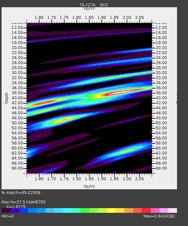
| Estimated Moho Depth: |
37.5 km |
| Estimated Crust Vp/Vs: |
1.98 |
| Assumed Crust Vp: |
6.129 km/s |
| Estimated Crust Vs: |
3.099 km/s |
| Estimated Crust Poisson's Ratio: |
0.33 |
|
| Radial Match: |
85.02506 % |
| Radial Bump: |
386 |
| Transverse Match: |
82.961586 % |
| Transverse Bump: |
380 |
| SOD ConfigId: |
2622 |
| Insert Time: |
2010-03-06 20:50:10.572 +0000 |
| GWidth: |
2.5 |
| Max Bumps: |
400 |
| Tol: |
0.001 |
|
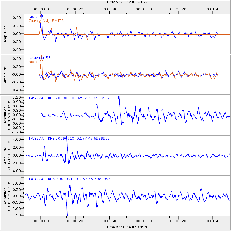
Signal To Noise
| Channel | StoN | STA | LTA |
| TA:Y27A: :BHZ:20090910T02:57:45.698999Z | 7.857601 | 8.794586E-7 | 1.11924564E-7 |
| TA:Y27A: :BHN:20090910T02:57:45.698999Z | 2.2762988 | 3.270482E-7 | 1.4367544E-7 |
| TA:Y27A: :BHE:20090910T02:57:45.698999Z | 3.7729473 | 3.3456118E-7 | 8.8673694E-8 |
| Arrivals |
| Ps | 6.1 SECOND |
| PpPs | 18 SECOND |
| PsPs/PpSs | 24 SECOND |


