You are here: Home > Network List > TA - USArray Transportable Network (new EarthScope stations) Stations List
> Station Y27A Causey, NM, USA > Earthquake Result Viewer
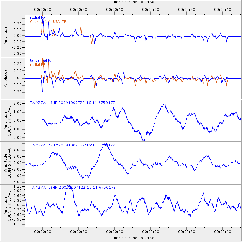
Y27A Causey, NM, USA - Earthquake Result Viewer

| Earthquake location: |
Vanuatu Islands |
| Earthquake latitude/longitude: |
-13.0/166.5 |
| Earthquake time(UTC): |
2009/10/07 (280) 22:03:14 GMT |
| Earthquake Depth: |
45 km |
| Earthquake Magnitude: |
6.4 MB, 7.3 MS, 7.6 MW, 7.7 MW |
| Earthquake Catalog/Contributor: |
WHDF/NEIC |
|
| Network: |
TA USArray Transportable Network (new EarthScope stations) |
| Station: |
Y27A Causey, NM, USA |
| Lat/Lon: |
33.88 N/103.16 W |
| Elevation: |
1253 m |
|
| Distance: |
97.4 deg |
| Az: |
57.02 deg |
| Baz: |
259.369 deg |
| Ray Param: |
0.04020001 |
| Estimated Moho Depth: |
24.5 km |
| Estimated Crust Vp/Vs: |
1.83 |
| Assumed Crust Vp: |
6.129 km/s |
| Estimated Crust Vs: |
3.349 km/s |
| Estimated Crust Poisson's Ratio: |
0.29 |
|
| Radial Match: |
83.68055 % |
| Radial Bump: |
400 |
| Transverse Match: |
61.004356 % |
| Transverse Bump: |
400 |
| SOD ConfigId: |
2622 |
| Insert Time: |
2010-03-06 20:50:14.797 +0000 |
| GWidth: |
2.5 |
| Max Bumps: |
400 |
| Tol: |
0.001 |
|
Signal To Noise
| Channel | StoN | STA | LTA |
| TA:Y27A: :BHZ:20091007T22:16:11.675017Z | 3.6697485 | 1.322707E-6 | 3.6043534E-7 |
| TA:Y27A: :BHN:20091007T22:16:11.675017Z | 1.0975343 | 3.1615602E-7 | 2.8806025E-7 |
| TA:Y27A: :BHE:20091007T22:16:11.675017Z | 1.1230733 | 3.4673386E-7 | 3.0873662E-7 |
| Arrivals |
| Ps | 3.4 SECOND |
| PpPs | 11 SECOND |
| PsPs/PpSs | 14 SECOND |


