You are here: Home > Network List > TA - USArray Transportable Network (new EarthScope stations) Stations List
> Station Y27A Causey, NM, USA > Earthquake Result Viewer
Y27A Causey, NM, USA - Earthquake Result Viewer
| Earthquake location: |
North Of Svalbard |
| Earthquake latitude/longitude: |
80.3/-1.9 |
| Earthquake time(UTC): |
2009/03/06 (065) 10:50:29 GMT |
| Earthquake Depth: |
9.0 km |
| Earthquake Magnitude: |
6.6 MB, 6.5 MS, 6.5 MW, 6.4 MW |
| Earthquake Catalog/Contributor: |
WHDF/NEIC |
|
| Network: |
TA USArray Transportable Network (new EarthScope stations) |
| Station: |
Y27A Causey, NM, USA |
| Lat/Lon: |
33.88 N/103.16 W |
| Elevation: |
1253 m |
|
| Distance: |
58.7 deg |
| Az: |
287.339 deg |
| Baz: |
11.193 deg |
| Ray Param: |
0.06266771 |
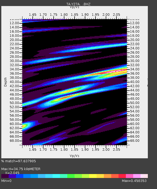
| Estimated Moho Depth: |
34.75 km |
| Estimated Crust Vp/Vs: |
2.05 |
| Assumed Crust Vp: |
6.129 km/s |
| Estimated Crust Vs: |
2.997 km/s |
| Estimated Crust Poisson's Ratio: |
0.34 |
|
| Radial Match: |
97.637985 % |
| Radial Bump: |
197 |
| Transverse Match: |
91.72072 % |
| Transverse Bump: |
393 |
| SOD ConfigId: |
2658 |
| Insert Time: |
2010-03-06 20:50:25.566 +0000 |
| GWidth: |
2.5 |
| Max Bumps: |
400 |
| Tol: |
0.001 |
|

Signal To Noise
| Channel | StoN | STA | LTA |
| TA:Y27A: :BHZ:20090306T10:59:56.250027Z | 27.77299 | 6.199212E-6 | 2.232101E-7 |
| TA:Y27A: :BHN:20090306T10:59:56.250027Z | 8.988157 | 2.8309048E-6 | 3.149594E-7 |
| TA:Y27A: :BHE:20090306T10:59:56.250027Z | 2.8383367 | 7.4834173E-7 | 2.63655E-7 |
| Arrivals |
| Ps | 6.2 SECOND |
| PpPs | 17 SECOND |
| PsPs/PpSs | 23 SECOND |


