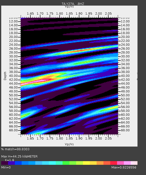
Y27A Causey, NM, USA - Earthquake Result Viewer
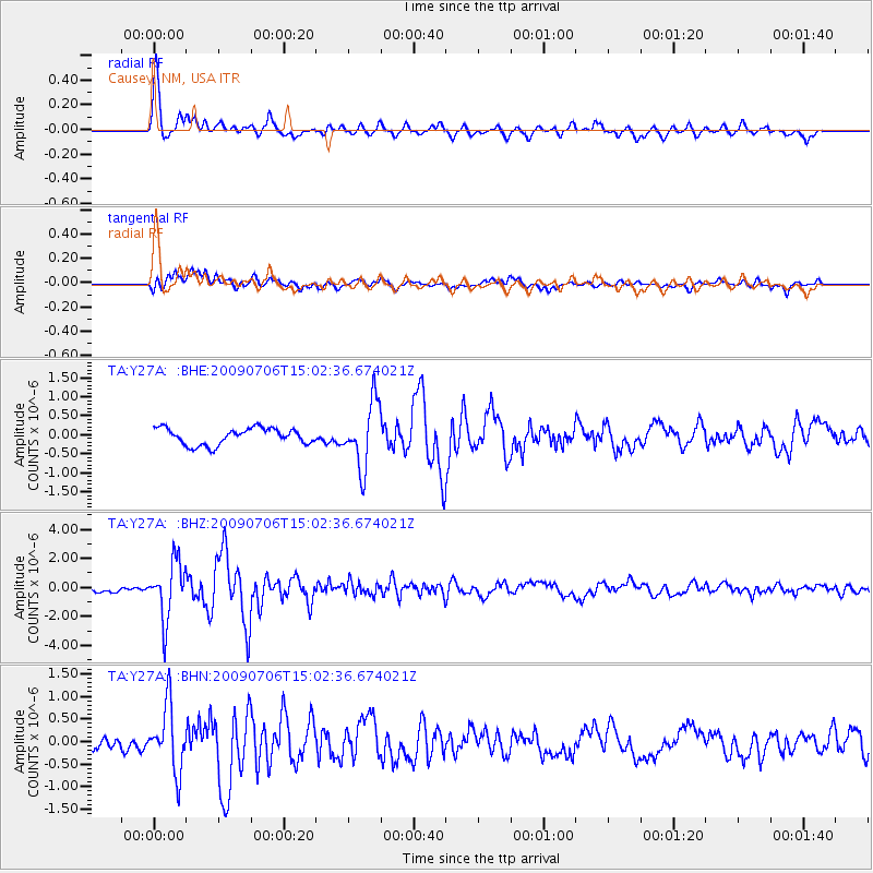
Earthquake location: Rat Islands, Aleutian Islands
Earthquake latitude/longitude: 50.4/177.0
Earthquake time(UTC): 2009/07/06 (187) 14:53:12 GMT
Earthquake Depth: 22 km
Earthquake Magnitude: 6.0 MB, 5.8 MS, 6.1 MW, 6.0 MW
Earthquake Catalog/Contributor: WHDF/NEIC
Network: TA USArray Transportable Network (new EarthScope stations)
Station: Y27A Causey, NM, USA
Lat/Lon: 33.88 N/103.16 W
Elevation: 1253 m
Distance: 58.6 deg
Az: 73.529 deg
Baz: 312.509 deg
Ray Param: 0.06268515
Estimated Moho Depth: 44.25 km
Estimated Crust Vp/Vs: 1.60
Assumed Crust Vp: 6.129 km/s
Estimated Crust Vs: 3.831 km/s
Estimated Crust Poisson's Ratio: 0.18
Radial Match: 88.8303 %
Radial Bump: 399
Transverse Match: 67.612656 %
Transverse Bump: 400
SOD ConfigId: 2648
Insert Time: 2010-03-06 20:50:30.970 +0000
GWidth: 2.5
Max Bumps: 400
Tol: 0.001

Signal To Noise

ChannelStoNSTALTA
TA:Y27A: :BHZ:20090706T15:02:36.674021Z9.2332671.951957E-62.1140481E-7
TA:Y27A: :BHN:20090706T15:02:36.674021Z2.97807057.247434E-72.4336006E-7
TA:Y27A: :BHE:20090706T15:02:36.674021Z3.9375128.529854E-72.1663055E-7
Arrivals
Ps4.5 SECOND
PpPs18 SECOND
PsPs/PpSs22 SECOND