You are here: Home > Network List > TA - USArray Transportable Network (new EarthScope stations) Stations List
> Station B18K Kokolik River, AK, USA > Earthquake Result Viewer
B18K Kokolik River, AK, USA - Earthquake Result Viewer
| Earthquake location: |
Turkey |
| Earthquake latitude/longitude: |
37.4/29.6 |
| Earthquake time(UTC): |
2019/03/20 (079) 06:34:28 GMT |
| Earthquake Depth: |
10 km |
| Earthquake Magnitude: |
5.7 Mww |
| Earthquake Catalog/Contributor: |
NEIC PDE/us |
|
| Network: |
TA USArray Transportable Network (new EarthScope stations) |
| Station: |
B18K Kokolik River, AK, USA |
| Lat/Lon: |
69.36 N/161.80 W |
| Elevation: |
222 m |
|
| Distance: |
73.2 deg |
| Az: |
4.185 deg |
| Baz: |
350.568 deg |
| Ray Param: |
0.05317094 |
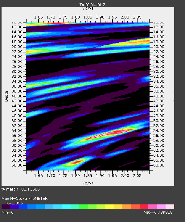
| Estimated Moho Depth: |
55.75 km |
| Estimated Crust Vp/Vs: |
1.89 |
| Assumed Crust Vp: |
5.906 km/s |
| Estimated Crust Vs: |
3.117 km/s |
| Estimated Crust Poisson's Ratio: |
0.31 |
|
| Radial Match: |
81.13606 % |
| Radial Bump: |
400 |
| Transverse Match: |
65.4632 % |
| Transverse Bump: |
400 |
| SOD ConfigId: |
13570011 |
| Insert Time: |
2019-05-02 18:32:27.366 +0000 |
| GWidth: |
2.5 |
| Max Bumps: |
400 |
| Tol: |
0.001 |
|

Signal To Noise
| Channel | StoN | STA | LTA |
| TA:B18K: :BHZ:20190320T06:45:28.100017Z | 8.343912 | 1.258749E-6 | 1.5085836E-7 |
| TA:B18K: :BHN:20190320T06:45:28.100017Z | 3.0163386 | 3.4860017E-7 | 1.1557063E-7 |
| TA:B18K: :BHE:20190320T06:45:28.100017Z | 0.8716664 | 1.3102827E-7 | 1.503193E-7 |
| Arrivals |
| Ps | 8.7 SECOND |
| PpPs | 27 SECOND |
| PsPs/PpSs | 35 SECOND |


