You are here: Home > Network List > TA - USArray Transportable Network (new EarthScope stations) Stations List
> Station G21K Allakaket, AK, USA > Earthquake Result Viewer
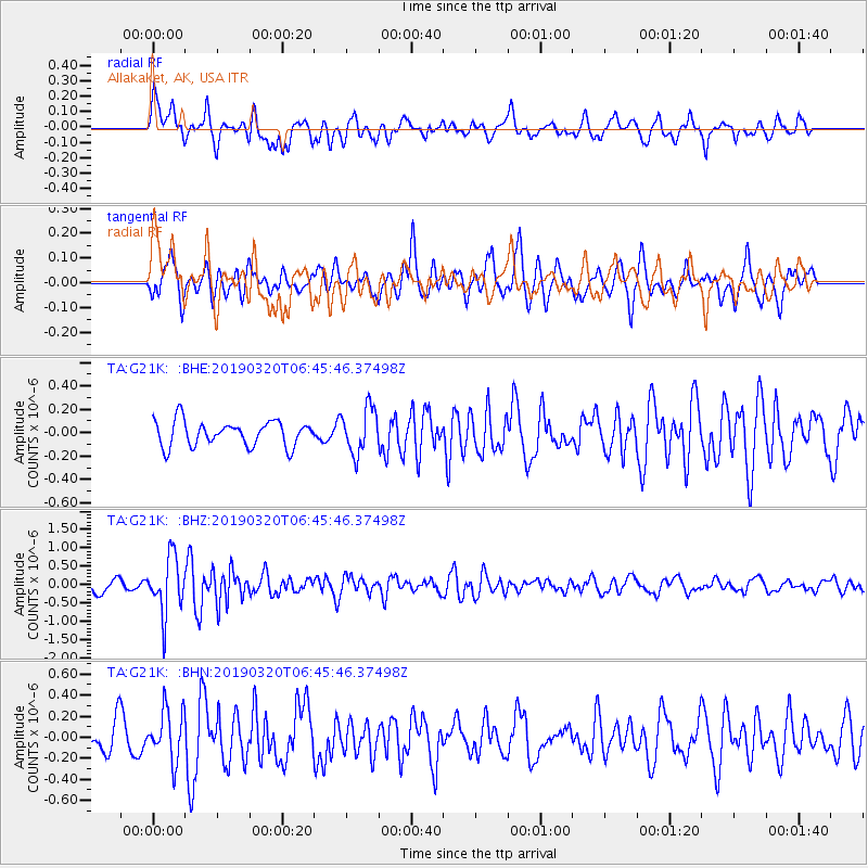
G21K Allakaket, AK, USA - Earthquake Result Viewer
*The percent match for this event was below the threshold and hence no stack was calculated.
| Earthquake location: |
Turkey |
| Earthquake latitude/longitude: |
37.4/29.6 |
| Earthquake time(UTC): |
2019/03/20 (079) 06:34:28 GMT |
| Earthquake Depth: |
10 km |
| Earthquake Magnitude: |
5.7 Mww |
| Earthquake Catalog/Contributor: |
NEIC PDE/us |
|
| Network: |
TA USArray Transportable Network (new EarthScope stations) |
| Station: |
G21K Allakaket, AK, USA |
| Lat/Lon: |
66.52 N/153.51 W |
| Elevation: |
446 m |
|
| Distance: |
76.4 deg |
| Az: |
1.265 deg |
| Baz: |
357.486 deg |
| Ray Param: |
$rayparam |
*The percent match for this event was below the threshold and hence was not used in the summary stack. |
|
| Radial Match: |
72.13466 % |
| Radial Bump: |
400 |
| Transverse Match: |
57.780865 % |
| Transverse Bump: |
400 |
| SOD ConfigId: |
13570011 |
| Insert Time: |
2019-05-02 18:33:03.544 +0000 |
| GWidth: |
2.5 |
| Max Bumps: |
400 |
| Tol: |
0.001 |
|
Signal To Noise
| Channel | StoN | STA | LTA |
| TA:G21K: :BHZ:20190320T06:45:46.37498Z | 4.205638 | 7.678992E-7 | 1.8258804E-7 |
| TA:G21K: :BHN:20190320T06:45:46.37498Z | 1.6346852 | 2.3684808E-7 | 1.4488911E-7 |
| TA:G21K: :BHE:20190320T06:45:46.37498Z | 1.8199949 | 1.9419605E-7 | 1.06701414E-7 |
| Arrivals |
| Ps | |
| PpPs | |
| PsPs/PpSs | |


