You are here: Home > Network List > TA - USArray Transportable Network (new EarthScope stations) Stations List
> Station Y27A Causey, NM, USA > Earthquake Result Viewer
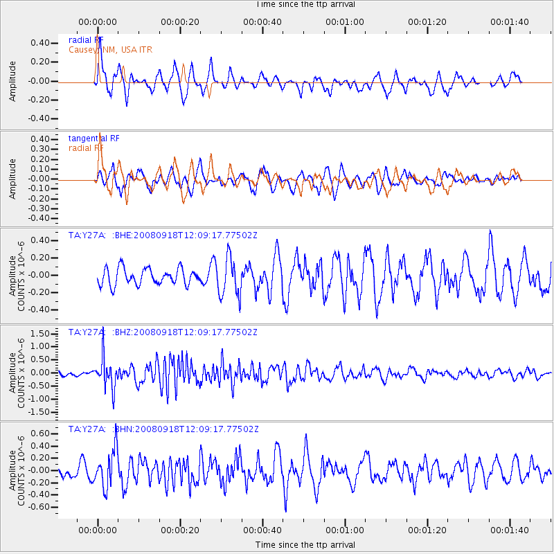
Y27A Causey, NM, USA - Earthquake Result Viewer
*The percent match for this event was below the threshold and hence no stack was calculated.
| Earthquake location: |
Near East Coast Of Kamchatka |
| Earthquake latitude/longitude: |
51.9/158.4 |
| Earthquake time(UTC): |
2008/09/18 (262) 11:58:50 GMT |
| Earthquake Depth: |
67 km |
| Earthquake Magnitude: |
5.7 MB, 5.9 MW, 5.8 MW |
| Earthquake Catalog/Contributor: |
WHDF/NEIC |
|
| Network: |
TA USArray Transportable Network (new EarthScope stations) |
| Station: |
Y27A Causey, NM, USA |
| Lat/Lon: |
33.88 N/103.16 W |
| Elevation: |
1253 m |
|
| Distance: |
68.9 deg |
| Az: |
61.884 deg |
| Baz: |
318.957 deg |
| Ray Param: |
$rayparam |
*The percent match for this event was below the threshold and hence was not used in the summary stack. |
|
| Radial Match: |
66.45538 % |
| Radial Bump: |
368 |
| Transverse Match: |
73.12377 % |
| Transverse Bump: |
400 |
| SOD ConfigId: |
2560 |
| Insert Time: |
2010-03-06 20:51:23.426 +0000 |
| GWidth: |
2.5 |
| Max Bumps: |
400 |
| Tol: |
0.001 |
|
Signal To Noise
| Channel | StoN | STA | LTA |
| TA:Y27A: :BHZ:20080918T12:09:17.77502Z | 6.4166937 | 5.7897046E-7 | 9.0228774E-8 |
| TA:Y27A: :BHN:20080918T12:09:17.77502Z | 3.480079 | 3.1341318E-7 | 9.005922E-8 |
| TA:Y27A: :BHE:20080918T12:09:17.77502Z | 2.4091282 | 2.2476299E-7 | 9.32964E-8 |
| Arrivals |
| Ps | |
| PpPs | |
| PsPs/PpSs | |


