You are here: Home > Network List > TA - USArray Transportable Network (new EarthScope stations) Stations List
> Station Y27A Causey, NM, USA > Earthquake Result Viewer
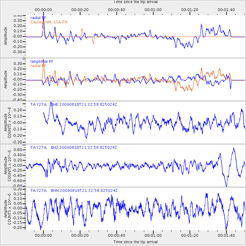
Y27A Causey, NM, USA - Earthquake Result Viewer
*The percent match for this event was below the threshold and hence no stack was calculated.
| Earthquake location: |
South Of Fiji Islands |
| Earthquake latitude/longitude: |
-26.1/-178.4 |
| Earthquake time(UTC): |
2009/08/18 (230) 21:20:47 GMT |
| Earthquake Depth: |
270 km |
| Earthquake Magnitude: |
5.5 MB, 6.3 MW, 6.3 MW |
| Earthquake Catalog/Contributor: |
WHDF/NEIC |
|
| Network: |
TA USArray Transportable Network (new EarthScope stations) |
| Station: |
Y27A Causey, NM, USA |
| Lat/Lon: |
33.88 N/103.16 W |
| Elevation: |
1253 m |
|
| Distance: |
93.0 deg |
| Az: |
53.656 deg |
| Baz: |
240.563 deg |
| Ray Param: |
$rayparam |
*The percent match for this event was below the threshold and hence was not used in the summary stack. |
|
| Radial Match: |
54.351948 % |
| Radial Bump: |
400 |
| Transverse Match: |
55.499714 % |
| Transverse Bump: |
400 |
| SOD ConfigId: |
2622 |
| Insert Time: |
2010-03-06 20:51:36.877 +0000 |
| GWidth: |
2.5 |
| Max Bumps: |
400 |
| Tol: |
0.001 |
|
Signal To Noise
| Channel | StoN | STA | LTA |
| TA:Y27A: :BHZ:20090818T21:32:58.825024Z | 3.437178 | 1.886272E-7 | 5.487851E-8 |
| TA:Y27A: :BHN:20090818T21:32:58.825024Z | 1.0541787 | 9.789729E-8 | 9.286594E-8 |
| TA:Y27A: :BHE:20090818T21:32:58.825024Z | 0.69565 | 7.9257624E-8 | 1.139332E-7 |
| Arrivals |
| Ps | |
| PpPs | |
| PsPs/PpSs | |


