You are here: Home > Network List > TS - TERRAscope (Southern California Seismic Network) Stations List
> Station DGR Domenigoni Valley Reservior, California, USA > Earthquake Result Viewer
DGR Domenigoni Valley Reservior, California, USA - Earthquake Result Viewer

| Earthquake location: |
Peru-Ecuador Border Region |
| Earthquake latitude/longitude: |
-2.8/-77.9 |
| Earthquake time(UTC): |
1995/10/03 (276) 01:51:24 GMT |
| Earthquake Depth: |
27 km |
| Earthquake Magnitude: |
6.5 MB, 7.0 MS, 6.9 UNKNOWN, 7.0 MW |
| Earthquake Catalog/Contributor: |
WHDF/NEIC |
|
| Network: |
TS TERRAscope (Southern California Seismic Network) |
| Station: |
DGR Domenigoni Valley Reservior, California, USA |
| Lat/Lon: |
33.65 N/117.01 W |
| Elevation: |
700 m |
|
| Distance: |
51.7 deg |
| Az: |
317.874 deg |
| Baz: |
126.564 deg |
| Ray Param: |
0.0671997 |
| Estimated Moho Depth: |
32.0 km |
| Estimated Crust Vp/Vs: |
1.77 |
| Assumed Crust Vp: |
6.264 km/s |
| Estimated Crust Vs: |
3.539 km/s |
| Estimated Crust Poisson's Ratio: |
0.27 |
|
| Radial Match: |
97.689835 % |
| Radial Bump: |
322 |
| Transverse Match: |
89.90273 % |
| Transverse Bump: |
400 |
| SOD ConfigId: |
6273 |
| Insert Time: |
2010-02-26 14:07:57.938 +0000 |
| GWidth: |
2.5 |
| Max Bumps: |
400 |
| Tol: |
0.001 |
|
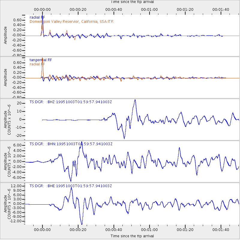
Signal To Noise
| Channel | StoN | STA | LTA |
| TS:DGR: :BHN:19951003T01:59:57.941003Z | 3.3661654 | 3.3528082E-7 | 9.960319E-8 |
| TS:DGR: :BHE:19951003T01:59:57.941003Z | 2.6581137 | 2.6264468E-7 | 9.880867E-8 |
| TS:DGR: :BHZ:19951003T01:59:57.941003Z | 3.1894805 | 6.560472E-7 | 2.0569092E-7 |
| Arrivals |
| Ps | 4.1 SECOND |
| PpPs | 13 SECOND |
| PsPs/PpSs | 18 SECOND |


