You are here: Home > Network List > TA - USArray Transportable Network (new EarthScope stations) Stations List
> Station Y27A Causey, NM, USA > Earthquake Result Viewer
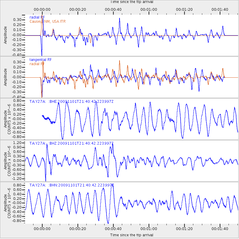
Y27A Causey, NM, USA - Earthquake Result Viewer
*The percent match for this event was below the threshold and hence no stack was calculated.
| Earthquake location: |
Tonga Islands |
| Earthquake latitude/longitude: |
-15.5/-173.8 |
| Earthquake time(UTC): |
2009/11/01 (305) 21:28:58 GMT |
| Earthquake Depth: |
105 km |
| Earthquake Magnitude: |
5.8 MW, 5.4 MB, 5.8 MW |
| Earthquake Catalog/Contributor: |
WHDF/NEIC |
|
| Network: |
TA USArray Transportable Network (new EarthScope stations) |
| Station: |
Y27A Causey, NM, USA |
| Lat/Lon: |
33.88 N/103.16 W |
| Elevation: |
1253 m |
|
| Distance: |
83.2 deg |
| Az: |
52.208 deg |
| Baz: |
246.318 deg |
| Ray Param: |
$rayparam |
*The percent match for this event was below the threshold and hence was not used in the summary stack. |
|
| Radial Match: |
61.942787 % |
| Radial Bump: |
380 |
| Transverse Match: |
39.222286 % |
| Transverse Bump: |
273 |
| SOD ConfigId: |
2622 |
| Insert Time: |
2010-03-06 20:51:47.860 +0000 |
| GWidth: |
2.5 |
| Max Bumps: |
400 |
| Tol: |
0.001 |
|
Signal To Noise
| Channel | StoN | STA | LTA |
| TA:Y27A: :BHZ:20091101T21:40:42.223997Z | 2.1042972 | 5.180273E-7 | 2.4617594E-7 |
| TA:Y27A: :BHN:20091101T21:40:42.223997Z | 1.7157583 | 3.9160614E-7 | 2.2824085E-7 |
| TA:Y27A: :BHE:20091101T21:40:42.223997Z | 1.1557841 | 4.579776E-7 | 3.9624837E-7 |
| Arrivals |
| Ps | |
| PpPs | |
| PsPs/PpSs | |


