You are here: Home > Network List > TS - TERRAscope (Southern California Seismic Network) Stations List
> Station DGR Domenigoni Valley Reservior, California, USA > Earthquake Result Viewer
DGR Domenigoni Valley Reservior, California, USA - Earthquake Result Viewer
| Earthquake location: |
Mariana Islands |
| Earthquake latitude/longitude: |
18.9/145.0 |
| Earthquake time(UTC): |
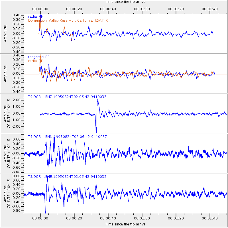
1995/08/24 (236) 01:55:34 GMT |
| Earthquake Depth: |
589 km |
| Earthquake Magnitude: |
5.9 MB, 6.2 UNKNOWN, 6.2 MW |
| Earthquake Catalog/Contributor: |
WHDF/NEIC |
|
| Network: |
TS TERRAscope (Southern California Seismic Network) |
| Station: |
DGR Domenigoni Valley Reservior, California, USA |
| Lat/Lon: |
33.65 N/117.01 W |
| Elevation: |
700 m |
|
| Distance: |
86.1 deg |
| Az: |
55.876 deg |
| Baz: |
290.038 deg |
| Ray Param: |
0.042560223 |
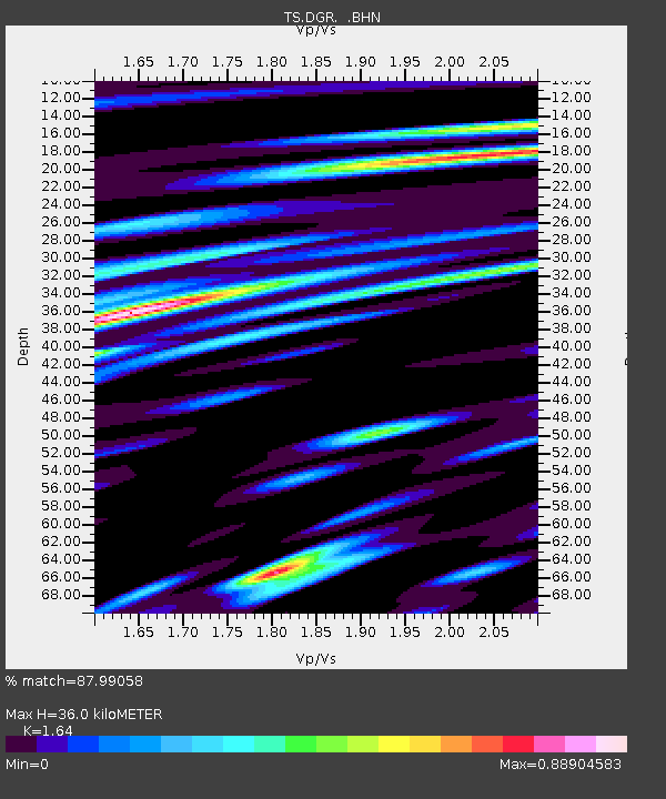
| Estimated Moho Depth: |
36.0 km |
| Estimated Crust Vp/Vs: |
1.64 |
| Assumed Crust Vp: |
6.264 km/s |
| Estimated Crust Vs: |
3.819 km/s |
| Estimated Crust Poisson's Ratio: |
0.20 |
|
| Radial Match: |
87.99058 % |
| Radial Bump: |
400 |
| Transverse Match: |
89.21477 % |
| Transverse Bump: |
400 |
| SOD ConfigId: |
6273 |
| Insert Time: |
2010-02-26 14:07:58.960 +0000 |
| GWidth: |
2.5 |
| Max Bumps: |
400 |
| Tol: |
0.001 |
|
Signal To Noise
| Channel | StoN | STA | LTA |
| TS:DGR: :BHN:19950824T02:06:42.941003Z | 4.587704 | 2.1360316E-7 | 4.6559922E-8 |
| TS:DGR: :BHE:19950824T02:06:42.941003Z | 7.2358694 | 3.6206455E-7 | 5.0037464E-8 |
| TS:DGR: :BHZ:19950824T02:06:42.941003Z | 16.763424 | 1.1326438E-6 | 6.756637E-8 |
| Arrivals |
| Ps | 3.8 SECOND |
| PpPs | 15 SECOND |
| PsPs/PpSs | 19 SECOND |


