You are here: Home > Network List > TA - USArray Transportable Network (new EarthScope stations) Stations List
> Station Y27A Causey, NM, USA > Earthquake Result Viewer
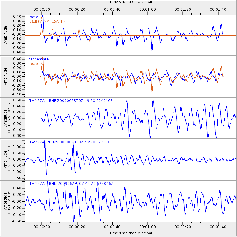
Y27A Causey, NM, USA - Earthquake Result Viewer
*The percent match for this event was below the threshold and hence no stack was calculated.
| Earthquake location: |
Near East Coast Of Honshu, Japan |
| Earthquake latitude/longitude: |
38.8/142.4 |
| Earthquake time(UTC): |
2009/06/23 (174) 07:37:17 GMT |
| Earthquake Depth: |
37 km |
| Earthquake Magnitude: |
5.7 MB, 5.0 MS, 5.6 MW, 5.6 MW |
| Earthquake Catalog/Contributor: |
WHDF/NEIC |
|
| Network: |
TA USArray Transportable Network (new EarthScope stations) |
| Station: |
Y27A Causey, NM, USA |
| Lat/Lon: |
33.88 N/103.16 W |
| Elevation: |
1253 m |
|
| Distance: |
85.5 deg |
| Az: |
49.43 deg |
| Baz: |
314.521 deg |
| Ray Param: |
$rayparam |
*The percent match for this event was below the threshold and hence was not used in the summary stack. |
|
| Radial Match: |
49.675434 % |
| Radial Bump: |
357 |
| Transverse Match: |
54.53709 % |
| Transverse Bump: |
376 |
| SOD ConfigId: |
2648 |
| Insert Time: |
2010-03-06 20:52:09.056 +0000 |
| GWidth: |
2.5 |
| Max Bumps: |
400 |
| Tol: |
0.001 |
|
Signal To Noise
| Channel | StoN | STA | LTA |
| TA:Y27A: :BHZ:20090623T07:49:20.624016Z | 7.659668 | 5.9489327E-7 | 7.7665675E-8 |
| TA:Y27A: :BHN:20090623T07:49:20.624016Z | 2.3047407 | 2.2943503E-7 | 9.9549176E-8 |
| TA:Y27A: :BHE:20090623T07:49:20.624016Z | 1.9518267 | 2.0289869E-7 | 1.0395323E-7 |
| Arrivals |
| Ps | |
| PpPs | |
| PsPs/PpSs | |


