You are here: Home > Network List > TA - USArray Transportable Network (new EarthScope stations) Stations List
> Station Y27A Causey, NM, USA > Earthquake Result Viewer
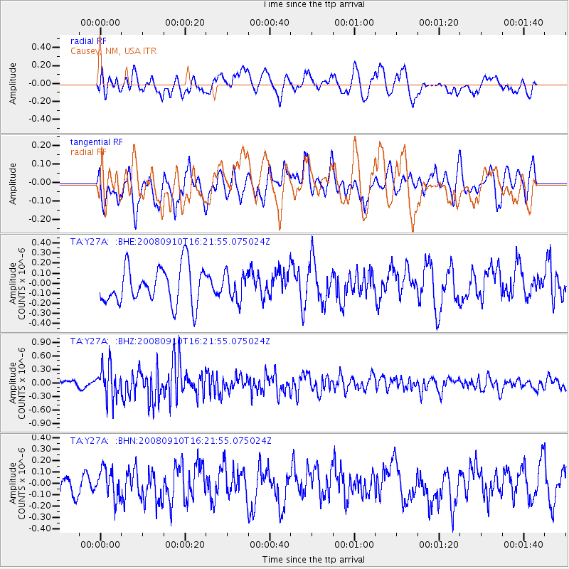
Y27A Causey, NM, USA - Earthquake Result Viewer
*The percent match for this event was below the threshold and hence no stack was calculated.
| Earthquake location: |
Northern Chile |
| Earthquake latitude/longitude: |
-20.3/-69.2 |
| Earthquake time(UTC): |
2008/09/10 (254) 16:12:04 GMT |
| Earthquake Depth: |
38 km |
| Earthquake Magnitude: |
5.6 MB, 5.3 MS |
| Earthquake Catalog/Contributor: |
WHDF/NEIC |
|
| Network: |
TA USArray Transportable Network (new EarthScope stations) |
| Station: |
Y27A Causey, NM, USA |
| Lat/Lon: |
33.88 N/103.16 W |
| Elevation: |
1253 m |
|
| Distance: |
62.8 deg |
| Az: |
328.523 deg |
| Baz: |
143.893 deg |
| Ray Param: |
$rayparam |
*The percent match for this event was below the threshold and hence was not used in the summary stack. |
|
| Radial Match: |
52.56442 % |
| Radial Bump: |
400 |
| Transverse Match: |
47.618176 % |
| Transverse Bump: |
400 |
| SOD ConfigId: |
2560 |
| Insert Time: |
2010-03-06 20:52:30.007 +0000 |
| GWidth: |
2.5 |
| Max Bumps: |
400 |
| Tol: |
0.001 |
|
Signal To Noise
| Channel | StoN | STA | LTA |
| TA:Y27A: :BHZ:20080910T16:21:55.075024Z | 2.8759236 | 3.6198108E-7 | 1.2586604E-7 |
| TA:Y27A: :BHN:20080910T16:21:55.075024Z | 1.0827931 | 1.2804705E-7 | 1.1825625E-7 |
| TA:Y27A: :BHE:20080910T16:21:55.075024Z | 0.7325043 | 1.3567512E-7 | 1.8522093E-7 |
| Arrivals |
| Ps | |
| PpPs | |
| PsPs/PpSs | |


