You are here: Home > Network List > TA - USArray Transportable Network (new EarthScope stations) Stations List
> Station B18K Kokolik River, AK, USA > Earthquake Result Viewer
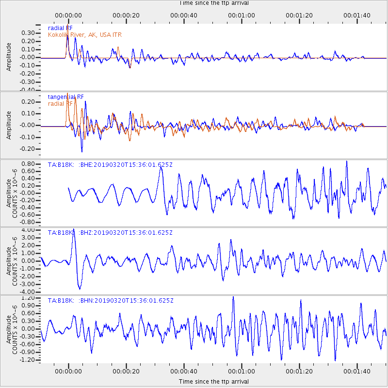
B18K Kokolik River, AK, USA - Earthquake Result Viewer
*The percent match for this event was below the threshold and hence no stack was calculated.
| Earthquake location: |
Vanuatu Islands |
| Earthquake latitude/longitude: |
-15.6/167.6 |
| Earthquake time(UTC): |
2019/03/20 (079) 15:23:59 GMT |
| Earthquake Depth: |
125 km |
| Earthquake Magnitude: |
6.2 Mww |
| Earthquake Catalog/Contributor: |
NEIC PDE/us |
|
| Network: |
TA USArray Transportable Network (new EarthScope stations) |
| Station: |
B18K Kokolik River, AK, USA |
| Lat/Lon: |
69.36 N/161.80 W |
| Elevation: |
222 m |
|
| Distance: |
87.5 deg |
| Az: |
10.404 deg |
| Baz: |
209.394 deg |
| Ray Param: |
$rayparam |
*The percent match for this event was below the threshold and hence was not used in the summary stack. |
|
| Radial Match: |
73.943214 % |
| Radial Bump: |
400 |
| Transverse Match: |
73.55619 % |
| Transverse Bump: |
400 |
| SOD ConfigId: |
13570011 |
| Insert Time: |
2019-05-02 18:42:54.364 +0000 |
| GWidth: |
2.5 |
| Max Bumps: |
400 |
| Tol: |
0.001 |
|
Signal To Noise
| Channel | StoN | STA | LTA |
| TA:B18K: :BHZ:20190320T15:36:01.625Z | 10.644824 | 2.284243E-6 | 2.145872E-7 |
| TA:B18K: :BHN:20190320T15:36:01.625Z | 1.5241965 | 2.9142063E-7 | 1.9119624E-7 |
| TA:B18K: :BHE:20190320T15:36:01.625Z | 2.7602656 | 4.0919753E-7 | 1.482457E-7 |
| Arrivals |
| Ps | |
| PpPs | |
| PsPs/PpSs | |


