You are here: Home > Network List > TA - USArray Transportable Network (new EarthScope stations) Stations List
> Station E19K Redstone River, AK, USA > Earthquake Result Viewer
E19K Redstone River, AK, USA - Earthquake Result Viewer
| Earthquake location: |
Vanuatu Islands |
| Earthquake latitude/longitude: |
-15.6/167.6 |
| Earthquake time(UTC): |
2019/03/20 (079) 15:23:59 GMT |
| Earthquake Depth: |
125 km |
| Earthquake Magnitude: |
6.2 Mww |
| Earthquake Catalog/Contributor: |
NEIC PDE/us |
|
| Network: |
TA USArray Transportable Network (new EarthScope stations) |
| Station: |
E19K Redstone River, AK, USA |
| Lat/Lon: |
67.46 N/157.23 W |
| Elevation: |
441 m |
|
| Distance: |
86.7 deg |
| Az: |
12.85 deg |
| Baz: |
213.763 deg |
| Ray Param: |
0.04355353 |
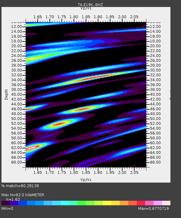
| Estimated Moho Depth: |
62.0 km |
| Estimated Crust Vp/Vs: |
1.62 |
| Assumed Crust Vp: |
6.577 km/s |
| Estimated Crust Vs: |
4.06 km/s |
| Estimated Crust Poisson's Ratio: |
0.19 |
|
| Radial Match: |
90.29139 % |
| Radial Bump: |
400 |
| Transverse Match: |
74.4549 % |
| Transverse Bump: |
400 |
| SOD ConfigId: |
13570011 |
| Insert Time: |
2019-05-02 18:43:11.182 +0000 |
| GWidth: |
2.5 |
| Max Bumps: |
400 |
| Tol: |
0.001 |
|

Signal To Noise
| Channel | StoN | STA | LTA |
| TA:E19K: :BHZ:20190320T15:35:58.025024Z | 17.992157 | 1.9959075E-6 | 1.1093208E-7 |
| TA:E19K: :BHN:20190320T15:35:58.025024Z | 4.886995 | 4.7931235E-7 | 9.8079155E-8 |
| TA:E19K: :BHE:20190320T15:35:58.025024Z | 3.8763678 | 4.4830344E-7 | 1.1565039E-7 |
| Arrivals |
| Ps | 6.0 SECOND |
| PpPs | 24 SECOND |
| PsPs/PpSs | 30 SECOND |


