You are here: Home > Network List > TA - USArray Transportable Network (new EarthScope stations) Stations List
> Station F19K Shaleruckik Mountain, AK, USA > Earthquake Result Viewer
F19K Shaleruckik Mountain, AK, USA - Earthquake Result Viewer
| Earthquake location: |
Vanuatu Islands |
| Earthquake latitude/longitude: |
-15.6/167.6 |
| Earthquake time(UTC): |
2019/03/20 (079) 15:23:59 GMT |
| Earthquake Depth: |
125 km |
| Earthquake Magnitude: |
6.2 Mww |
| Earthquake Catalog/Contributor: |
NEIC PDE/us |
|
| Network: |
TA USArray Transportable Network (new EarthScope stations) |
| Station: |
F19K Shaleruckik Mountain, AK, USA |
| Lat/Lon: |
66.83 N/157.77 W |
| Elevation: |
161 m |
|
| Distance: |
86.1 deg |
| Az: |
13.02 deg |
| Baz: |
213.276 deg |
| Ray Param: |
0.04401876 |
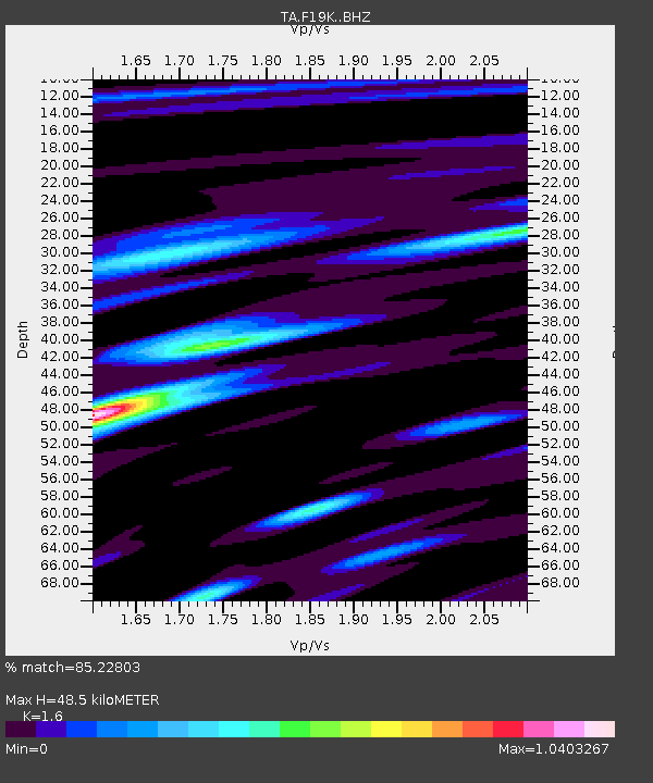
| Estimated Moho Depth: |
48.5 km |
| Estimated Crust Vp/Vs: |
1.60 |
| Assumed Crust Vp: |
6.577 km/s |
| Estimated Crust Vs: |
4.11 km/s |
| Estimated Crust Poisson's Ratio: |
0.18 |
|
| Radial Match: |
85.22803 % |
| Radial Bump: |
400 |
| Transverse Match: |
74.3705 % |
| Transverse Bump: |
400 |
| SOD ConfigId: |
13570011 |
| Insert Time: |
2019-05-02 18:43:22.011 +0000 |
| GWidth: |
2.5 |
| Max Bumps: |
400 |
| Tol: |
0.001 |
|

Signal To Noise
| Channel | StoN | STA | LTA |
| TA:F19K: :BHZ:20190320T15:35:54.924988Z | 13.808342 | 2.0563707E-6 | 1.4892235E-7 |
| TA:F19K: :BHN:20190320T15:35:54.924988Z | 3.3989177 | 4.8603647E-7 | 1.4299742E-7 |
| TA:F19K: :BHE:20190320T15:35:54.924988Z | 4.4563584 | 5.018248E-7 | 1.1260871E-7 |
| Arrivals |
| Ps | 4.5 SECOND |
| PpPs | 19 SECOND |
| PsPs/PpSs | 23 SECOND |


