You are here: Home > Network List > TA - USArray Transportable Network (new EarthScope stations) Stations List
> Station W26A Owens Ranch, Tucumcari, NM, USA > Earthquake Result Viewer
W26A Owens Ranch, Tucumcari, NM, USA - Earthquake Result Viewer

| Earthquake location: |
Kermadec Islands Region |
| Earthquake latitude/longitude: |
-27.4/-176.3 |
| Earthquake time(UTC): |
2009/02/18 (049) 21:53:45 GMT |
| Earthquake Depth: |
25 km |
| Earthquake Magnitude: |
6.8 MB, 7.2 MS, 6.9 MW, 6.9 MW |
| Earthquake Catalog/Contributor: |
WHDF/NEIC |
|
| Network: |
TA USArray Transportable Network (new EarthScope stations) |
| Station: |
W26A Owens Ranch, Tucumcari, NM, USA |
| Lat/Lon: |
35.09 N/103.77 W |
| Elevation: |
1314 m |
|
| Distance: |
92.5 deg |
| Az: |
51.549 deg |
| Baz: |
238.087 deg |
| Ray Param: |
0.041437697 |
| Estimated Moho Depth: |
49.0 km |
| Estimated Crust Vp/Vs: |
1.93 |
| Assumed Crust Vp: |
6.242 km/s |
| Estimated Crust Vs: |
3.234 km/s |
| Estimated Crust Poisson's Ratio: |
0.32 |
|
| Radial Match: |
91.6661 % |
| Radial Bump: |
358 |
| Transverse Match: |
83.91552 % |
| Transverse Bump: |
400 |
| SOD ConfigId: |
2658 |
| Insert Time: |
2010-03-06 20:53:00.956 +0000 |
| GWidth: |
2.5 |
| Max Bumps: |
400 |
| Tol: |
0.001 |
|
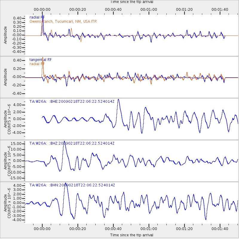
Signal To Noise
| Channel | StoN | STA | LTA |
| TA:W26A: :BHZ:20090218T22:06:22.524014Z | 8.418004 | 1.9761349E-6 | 2.34751E-7 |
| TA:W26A: :BHN:20090218T22:06:22.524014Z | 1.5921857 | 4.6392793E-7 | 2.9137803E-7 |
| TA:W26A: :BHE:20090218T22:06:22.524014Z | 0.91936934 | 5.073872E-7 | 5.5188616E-7 |
| Arrivals |
| Ps | 7.4 SECOND |
| PpPs | 23 SECOND |
| PsPs/PpSs | 30 SECOND |


