You are here: Home > Network List > TA - USArray Transportable Network (new EarthScope stations) Stations List
> Station G19K Purcell Mountains, AK, USA > Earthquake Result Viewer
G19K Purcell Mountains, AK, USA - Earthquake Result Viewer
| Earthquake location: |
Vanuatu Islands |
| Earthquake latitude/longitude: |
-15.6/167.6 |
| Earthquake time(UTC): |
2019/03/20 (079) 15:23:59 GMT |
| Earthquake Depth: |
125 km |
| Earthquake Magnitude: |
6.2 Mww |
| Earthquake Catalog/Contributor: |
NEIC PDE/us |
|
| Network: |
TA USArray Transportable Network (new EarthScope stations) |
| Station: |
G19K Purcell Mountains, AK, USA |
| Lat/Lon: |
66.14 N/157.09 W |
| Elevation: |
391 m |
|
| Distance: |
85.7 deg |
| Az: |
13.635 deg |
| Baz: |
213.948 deg |
| Ray Param: |
0.044318024 |
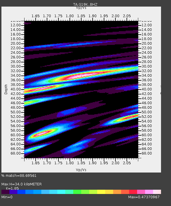
| Estimated Moho Depth: |
34.0 km |
| Estimated Crust Vp/Vs: |
1.85 |
| Assumed Crust Vp: |
6.577 km/s |
| Estimated Crust Vs: |
3.555 km/s |
| Estimated Crust Poisson's Ratio: |
0.29 |
|
| Radial Match: |
88.69561 % |
| Radial Bump: |
382 |
| Transverse Match: |
58.118828 % |
| Transverse Bump: |
400 |
| SOD ConfigId: |
13570011 |
| Insert Time: |
2019-05-02 18:43:31.644 +0000 |
| GWidth: |
2.5 |
| Max Bumps: |
400 |
| Tol: |
0.001 |
|

Signal To Noise
| Channel | StoN | STA | LTA |
| TA:G19K: :BHZ:20190320T15:35:52.825012Z | 13.454636 | 2.0093335E-6 | 1.4934135E-7 |
| TA:G19K: :BHN:20190320T15:35:52.825012Z | 7.4105816 | 7.770929E-7 | 1.0486261E-7 |
| TA:G19K: :BHE:20190320T15:35:52.825012Z | 4.92627 | 5.2192564E-7 | 1.0594742E-7 |
| Arrivals |
| Ps | 4.5 SECOND |
| PpPs | 14 SECOND |
| PsPs/PpSs | 19 SECOND |


