You are here: Home > Network List > TS - TERRAscope (Southern California Seismic Network) Stations List
> Station DGR Domenigoni Valley Reservior, California, USA > Earthquake Result Viewer
DGR Domenigoni Valley Reservior, California, USA - Earthquake Result Viewer

| Earthquake location: |
Solomon Islands |
| Earthquake latitude/longitude: |
-5.8/154.2 |
| Earthquake time(UTC): |
1995/08/16 (228) 10:27:26 GMT |
| Earthquake Depth: |
16 km |
| Earthquake Magnitude: |
6.4 MB, 7.8 MS, 7.8 UNKNOWN, 7.8 MW |
| Earthquake Catalog/Contributor: |
WHDF/NEIC |
|
| Network: |
TS TERRAscope (Southern California Seismic Network) |
| Station: |
DGR Domenigoni Valley Reservior, California, USA |
| Lat/Lon: |
33.65 N/117.01 W |
| Elevation: |
700 m |
|
| Distance: |
92.2 deg |
| Az: |
56.569 deg |
| Baz: |
264.513 deg |
| Ray Param: |
0.041497592 |
| Estimated Moho Depth: |
31.25 km |
| Estimated Crust Vp/Vs: |
1.86 |
| Assumed Crust Vp: |
6.264 km/s |
| Estimated Crust Vs: |
3.372 km/s |
| Estimated Crust Poisson's Ratio: |
0.30 |
|
| Radial Match: |
95.65374 % |
| Radial Bump: |
400 |
| Transverse Match: |
85.34452 % |
| Transverse Bump: |
400 |
| SOD ConfigId: |
6273 |
| Insert Time: |
2010-02-26 14:08:03.293 +0000 |
| GWidth: |
2.5 |
| Max Bumps: |
400 |
| Tol: |
0.001 |
|
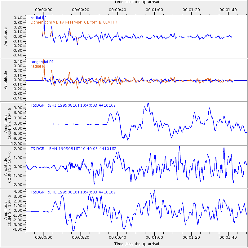
Signal To Noise
| Channel | StoN | STA | LTA |
| TS:DGR: :BHN:19950816T10:40:03.441016Z | 0.5206608 | 5.7776546E-8 | 1.10967726E-7 |
| TS:DGR: :BHE:19950816T10:40:03.441016Z | 1.9401797 | 1.3453096E-7 | 6.9339436E-8 |
| TS:DGR: :BHZ:19950816T10:40:03.441016Z | 2.546246 | 3.3495257E-7 | 1.315476E-7 |
| Arrivals |
| Ps | 4.4 SECOND |
| PpPs | 14 SECOND |
| PsPs/PpSs | 18 SECOND |


