You are here: Home > Network List > TA - USArray Transportable Network (new EarthScope stations) Stations List
> Station I17K Unalakleet, AK, USA > Earthquake Result Viewer
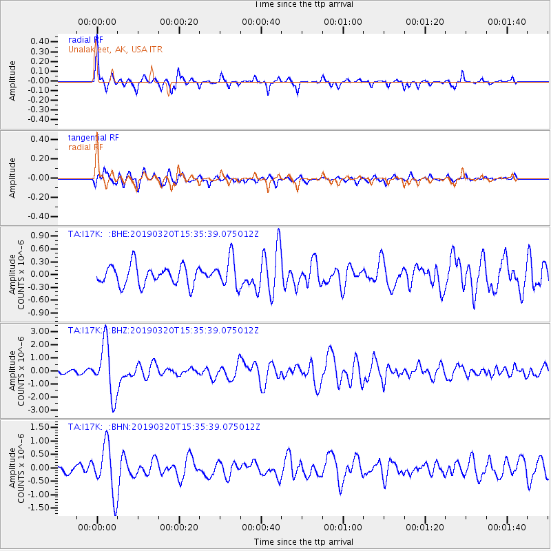
I17K Unalakleet, AK, USA - Earthquake Result Viewer
*The percent match for this event was below the threshold and hence no stack was calculated.
| Earthquake location: |
Vanuatu Islands |
| Earthquake latitude/longitude: |
-15.6/167.6 |
| Earthquake time(UTC): |
2019/03/20 (079) 15:23:59 GMT |
| Earthquake Depth: |
125 km |
| Earthquake Magnitude: |
6.2 Mww |
| Earthquake Catalog/Contributor: |
NEIC PDE/us |
|
| Network: |
TA USArray Transportable Network (new EarthScope stations) |
| Station: |
I17K Unalakleet, AK, USA |
| Lat/Lon: |
63.89 N/160.70 W |
| Elevation: |
105 m |
|
| Distance: |
82.9 deg |
| Az: |
13.55 deg |
| Baz: |
210.672 deg |
| Ray Param: |
$rayparam |
*The percent match for this event was below the threshold and hence was not used in the summary stack. |
|
| Radial Match: |
74.118515 % |
| Radial Bump: |
277 |
| Transverse Match: |
73.15637 % |
| Transverse Bump: |
400 |
| SOD ConfigId: |
13570011 |
| Insert Time: |
2019-05-02 18:43:46.320 +0000 |
| GWidth: |
2.5 |
| Max Bumps: |
400 |
| Tol: |
0.001 |
|
Signal To Noise
| Channel | StoN | STA | LTA |
| TA:I17K: :BHZ:20190320T15:35:39.075012Z | 9.235003 | 2.0707425E-6 | 2.2422758E-7 |
| TA:I17K: :BHN:20190320T15:35:39.075012Z | 3.49455 | 9.4363514E-7 | 2.700305E-7 |
| TA:I17K: :BHE:20190320T15:35:39.075012Z | 1.609351 | 3.6647901E-7 | 2.277185E-7 |
| Arrivals |
| Ps | |
| PpPs | |
| PsPs/PpSs | |


