You are here: Home > Network List > TA - USArray Transportable Network (new EarthScope stations) Stations List
> Station J20K Nowitna River, AK, USA > Earthquake Result Viewer
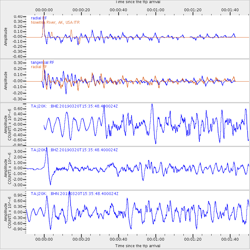
J20K Nowitna River, AK, USA - Earthquake Result Viewer
*The percent match for this event was below the threshold and hence no stack was calculated.
| Earthquake location: |
Vanuatu Islands |
| Earthquake latitude/longitude: |
-15.6/167.6 |
| Earthquake time(UTC): |
2019/03/20 (079) 15:23:59 GMT |
| Earthquake Depth: |
125 km |
| Earthquake Magnitude: |
6.2 Mww |
| Earthquake Catalog/Contributor: |
NEIC PDE/us |
|
| Network: |
TA USArray Transportable Network (new EarthScope stations) |
| Station: |
J20K Nowitna River, AK, USA |
| Lat/Lon: |
64.18 N/154.15 W |
| Elevation: |
314 m |
|
| Distance: |
84.8 deg |
| Az: |
15.798 deg |
| Baz: |
216.793 deg |
| Ray Param: |
$rayparam |
*The percent match for this event was below the threshold and hence was not used in the summary stack. |
|
| Radial Match: |
73.76181 % |
| Radial Bump: |
281 |
| Transverse Match: |
65.37404 % |
| Transverse Bump: |
400 |
| SOD ConfigId: |
13570011 |
| Insert Time: |
2019-05-02 18:43:55.653 +0000 |
| GWidth: |
2.5 |
| Max Bumps: |
400 |
| Tol: |
0.001 |
|
Signal To Noise
| Channel | StoN | STA | LTA |
| TA:J20K: :BHZ:20190320T15:35:48.400024Z | 10.867906 | 1.8779768E-6 | 1.7280026E-7 |
| TA:J20K: :BHN:20190320T15:35:48.400024Z | 2.259676 | 4.7643377E-7 | 2.1084162E-7 |
| TA:J20K: :BHE:20190320T15:35:48.400024Z | 1.3995144 | 3.343547E-7 | 2.3890763E-7 |
| Arrivals |
| Ps | |
| PpPs | |
| PsPs/PpSs | |


