You are here: Home > Network List > TA - USArray Transportable Network (new EarthScope stations) Stations List
> Station W26A Owens Ranch, Tucumcari, NM, USA > Earthquake Result Viewer
W26A Owens Ranch, Tucumcari, NM, USA - Earthquake Result Viewer
| Earthquake location: |
Kuril Islands |
| Earthquake latitude/longitude: |
46.0/151.4 |
| Earthquake time(UTC): |
2009/04/18 (108) 19:17:58 GMT |
| Earthquake Depth: |
35 km |
| Earthquake Magnitude: |
6.3 MB, 6.3 MS, 6.6 MW, 6.4 MW |
| Earthquake Catalog/Contributor: |
WHDF/NEIC |
|
| Network: |
TA USArray Transportable Network (new EarthScope stations) |
| Station: |
W26A Owens Ranch, Tucumcari, NM, USA |
| Lat/Lon: |
35.09 N/103.77 W |
| Elevation: |
1314 m |
|
| Distance: |
74.7 deg |
| Az: |
55.294 deg |
| Baz: |
315.686 deg |
| Ray Param: |
0.05212473 |
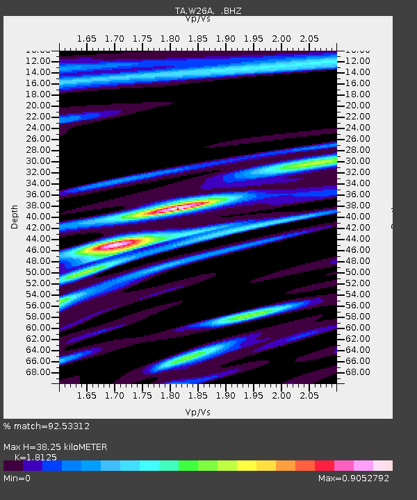
| Estimated Moho Depth: |
38.25 km |
| Estimated Crust Vp/Vs: |
1.81 |
| Assumed Crust Vp: |
6.242 km/s |
| Estimated Crust Vs: |
3.444 km/s |
| Estimated Crust Poisson's Ratio: |
0.28 |
|
| Radial Match: |
92.53312 % |
| Radial Bump: |
400 |
| Transverse Match: |
86.20688 % |
| Transverse Bump: |
400 |
| SOD ConfigId: |
2658 |
| Insert Time: |
2010-03-06 20:53:23.332 +0000 |
| GWidth: |
2.5 |
| Max Bumps: |
400 |
| Tol: |
0.001 |
|

Signal To Noise
| Channel | StoN | STA | LTA |
| TA:W26A: :BHZ:20090418T19:29:03.875007Z | 12.662416 | 1.8770264E-6 | 1.4823604E-7 |
| TA:W26A: :BHN:20090418T19:29:03.875007Z | 2.0973074 | 4.3650144E-7 | 2.0812469E-7 |
| TA:W26A: :BHE:20090418T19:29:03.875007Z | 1.6728736 | 2.550128E-7 | 1.5243997E-7 |
| Arrivals |
| Ps | 5.1 SECOND |
| PpPs | 17 SECOND |
| PsPs/PpSs | 22 SECOND |


