You are here: Home > Network List > TA - USArray Transportable Network (new EarthScope stations) Stations List
> Station W26A Owens Ranch, Tucumcari, NM, USA > Earthquake Result Viewer
W26A Owens Ranch, Tucumcari, NM, USA - Earthquake Result Viewer
| Earthquake location: |
Near Coast Of Central Chile |
| Earthquake latitude/longitude: |
-32.5/-71.7 |
| Earthquake time(UTC): |
2008/12/18 (353) 21:19:28 GMT |
| Earthquake Depth: |
18 km |
| Earthquake Magnitude: |
5.8 MB, 6.0 MS, 6.2 MW, 6.1 MW |
| Earthquake Catalog/Contributor: |
WHDF/NEIC |
|
| Network: |
TA USArray Transportable Network (new EarthScope stations) |
| Station: |
W26A Owens Ranch, Tucumcari, NM, USA |
| Lat/Lon: |
35.09 N/103.77 W |
| Elevation: |
1314 m |
|
| Distance: |
73.6 deg |
| Az: |
333.034 deg |
| Baz: |
152.13 deg |
| Ray Param: |
0.052868616 |
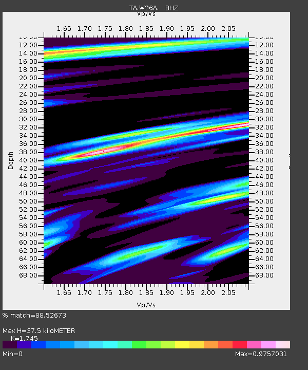
| Estimated Moho Depth: |
37.5 km |
| Estimated Crust Vp/Vs: |
1.75 |
| Assumed Crust Vp: |
6.242 km/s |
| Estimated Crust Vs: |
3.577 km/s |
| Estimated Crust Poisson's Ratio: |
0.26 |
|
| Radial Match: |
88.52673 % |
| Radial Bump: |
400 |
| Transverse Match: |
65.63294 % |
| Transverse Bump: |
400 |
| SOD ConfigId: |
2658 |
| Insert Time: |
2010-03-06 20:53:28.325 +0000 |
| GWidth: |
2.5 |
| Max Bumps: |
400 |
| Tol: |
0.001 |
|
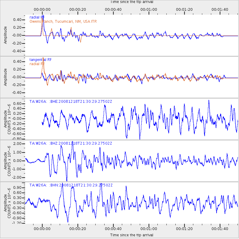
Signal To Noise
| Channel | StoN | STA | LTA |
| TA:W26A: :BHZ:20081218T21:30:29.27502Z | 6.1963606 | 7.4303847E-7 | 1.1991531E-7 |
| TA:W26A: :BHN:20081218T21:30:29.27502Z | 0.7438494 | 1.2825309E-7 | 1.7241808E-7 |
| TA:W26A: :BHE:20081218T21:30:29.27502Z | 1.1681912 | 1.8853659E-7 | 1.613919E-7 |
| Arrivals |
| Ps | 4.6 SECOND |
| PpPs | 16 SECOND |
| PsPs/PpSs | 21 SECOND |


