You are here: Home > Network List > TA - USArray Transportable Network (new EarthScope stations) Stations List
> Station W26A Owens Ranch, Tucumcari, NM, USA > Earthquake Result Viewer
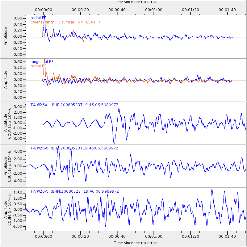
W26A Owens Ranch, Tucumcari, NM, USA - Earthquake Result Viewer

| Earthquake location: |
Central Mid-Atlantic Ridge |
| Earthquake latitude/longitude: |
7.3/-34.9 |
| Earthquake time(UTC): |
2008/05/23 (144) 19:35:34 GMT |
| Earthquake Depth: |
9.0 km |
| Earthquake Magnitude: |
6.0 MB, 6.4 MS, 6.5 MW, 6.5 MW |
| Earthquake Catalog/Contributor: |
WHDF/NEIC |
|
| Network: |
TA USArray Transportable Network (new EarthScope stations) |
| Station: |
W26A Owens Ranch, Tucumcari, NM, USA |
| Lat/Lon: |
35.09 N/103.77 W |
| Elevation: |
1314 m |
|
| Distance: |
68.6 deg |
| Az: |
304.732 deg |
| Baz: |
96.227 deg |
| Ray Param: |
0.056230288 |
| Estimated Moho Depth: |
33.25 km |
| Estimated Crust Vp/Vs: |
1.99 |
| Assumed Crust Vp: |
6.242 km/s |
| Estimated Crust Vs: |
3.141 km/s |
| Estimated Crust Poisson's Ratio: |
0.33 |
|
| Radial Match: |
82.68465 % |
| Radial Bump: |
388 |
| Transverse Match: |
79.62333 % |
| Transverse Bump: |
400 |
| SOD ConfigId: |
2504 |
| Insert Time: |
2010-03-06 20:53:44.668 +0000 |
| GWidth: |
2.5 |
| Max Bumps: |
400 |
| Tol: |
0.001 |
|
Signal To Noise
| Channel | StoN | STA | LTA |
| TA:W26A: :BHZ:20080523T19:46:06.598997Z | 3.4982378 | 1.0695968E-6 | 3.0575302E-7 |
| TA:W26A: :BHN:20080523T19:46:06.598997Z | 1.9278295 | 4.385456E-7 | 2.2748152E-7 |
| TA:W26A: :BHE:20080523T19:46:06.598997Z | 1.8164638 | 7.887398E-7 | 4.3421716E-7 |
| Arrivals |
| Ps | 5.4 SECOND |
| PpPs | 15 SECOND |
| PsPs/PpSs | 21 SECOND |


