You are here: Home > Network List > TA - USArray Transportable Network (new EarthScope stations) Stations List
> Station W26A Owens Ranch, Tucumcari, NM, USA > Earthquake Result Viewer
W26A Owens Ranch, Tucumcari, NM, USA - Earthquake Result Viewer
| Earthquake location: |
Southern East Pacific Rise |
| Earthquake latitude/longitude: |
-36.6/-107.4 |
| Earthquake time(UTC): |
2008/06/15 (167) 08:37:17 GMT |
| Earthquake Depth: |
10 km |
| Earthquake Magnitude: |
5.5 MB, 5.4 MS, 6.0 MW, 6.0 MW |
| Earthquake Catalog/Contributor: |
WHDF/NEIC |
|
| Network: |
TA USArray Transportable Network (new EarthScope stations) |
| Station: |
W26A Owens Ranch, Tucumcari, NM, USA |
| Lat/Lon: |
35.09 N/103.77 W |
| Elevation: |
1314 m |
|
| Distance: |
71.4 deg |
| Az: |
3.187 deg |
| Baz: |
183.126 deg |
| Ray Param: |
0.05433389 |
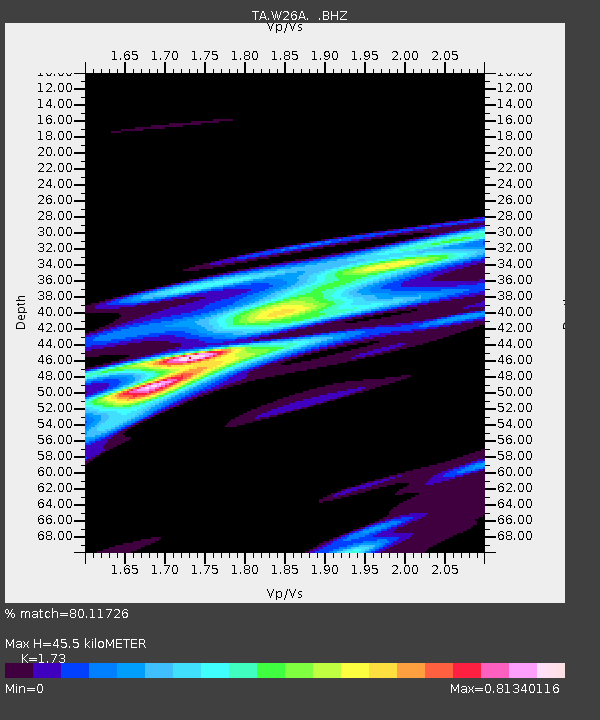
| Estimated Moho Depth: |
45.5 km |
| Estimated Crust Vp/Vs: |
1.73 |
| Assumed Crust Vp: |
6.242 km/s |
| Estimated Crust Vs: |
3.608 km/s |
| Estimated Crust Poisson's Ratio: |
0.25 |
|
| Radial Match: |
80.11726 % |
| Radial Bump: |
400 |
| Transverse Match: |
71.12442 % |
| Transverse Bump: |
400 |
| SOD ConfigId: |
2504 |
| Insert Time: |
2010-03-06 20:53:47.887 +0000 |
| GWidth: |
2.5 |
| Max Bumps: |
400 |
| Tol: |
0.001 |
|

Signal To Noise
| Channel | StoN | STA | LTA |
| TA:W26A: :BHZ:20080615T08:48:06.325Z | 4.8557096 | 4.2117773E-7 | 8.673866E-8 |
| TA:W26A: :BHN:20080615T08:48:06.325Z | 2.4954839 | 3.4184745E-7 | 1.3698644E-7 |
| TA:W26A: :BHE:20080615T08:48:06.325Z | 1.1188569 | 9.173265E-8 | 8.198783E-8 |
| Arrivals |
| Ps | 5.5 SECOND |
| PpPs | 19 SECOND |
| PsPs/PpSs | 25 SECOND |


