You are here: Home > Network List > UW - Pacific Northwest Regional Seismic Network Stations List
> Station LEBA Lebam, WA, USA > Earthquake Result Viewer
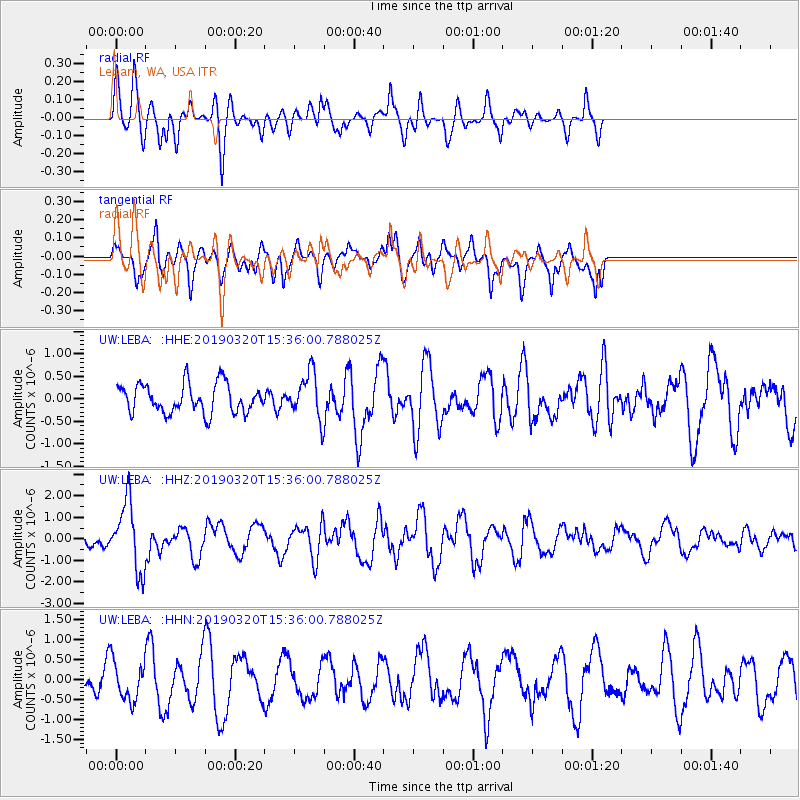
LEBA Lebam, WA, USA - Earthquake Result Viewer
*The percent match for this event was below the threshold and hence no stack was calculated.
| Earthquake location: |
Vanuatu Islands |
| Earthquake latitude/longitude: |
-15.6/167.6 |
| Earthquake time(UTC): |
2019/03/20 (079) 15:23:59 GMT |
| Earthquake Depth: |
125 km |
| Earthquake Magnitude: |
6.2 Mww |
| Earthquake Catalog/Contributor: |
NEIC PDE/us |
|
| Network: |
UW Pacific Northwest Regional Seismic Network |
| Station: |
LEBA Lebam, WA, USA |
| Lat/Lon: |
46.55 N/123.56 W |
| Elevation: |
73 m |
|
| Distance: |
87.3 deg |
| Az: |
40.115 deg |
| Baz: |
244.089 deg |
| Ray Param: |
$rayparam |
*The percent match for this event was below the threshold and hence was not used in the summary stack. |
|
| Radial Match: |
65.20099 % |
| Radial Bump: |
400 |
| Transverse Match: |
66.09593 % |
| Transverse Bump: |
375 |
| SOD ConfigId: |
13570011 |
| Insert Time: |
2019-05-02 18:45:58.396 +0000 |
| GWidth: |
2.5 |
| Max Bumps: |
400 |
| Tol: |
0.001 |
|
Signal To Noise
| Channel | StoN | STA | LTA |
| UW:LEBA: :HHZ:20190320T15:36:00.788025Z | 5.604423 | 1.5889007E-6 | 2.8350834E-7 |
| UW:LEBA: :HHN:20190320T15:36:00.788025Z | 0.8780715 | 4.784957E-7 | 5.449393E-7 |
| UW:LEBA: :HHE:20190320T15:36:00.788025Z | 1.6908284 | 5.370102E-7 | 3.1760183E-7 |
| Arrivals |
| Ps | |
| PpPs | |
| PsPs/PpSs | |


