You are here: Home > Network List > TS - TERRAscope (Southern California Seismic Network) Stations List
> Station DGR Domenigoni Valley Reservior, California, USA > Earthquake Result Viewer
DGR Domenigoni Valley Reservior, California, USA - Earthquake Result Viewer
| Earthquake location: |
Kuril Islands |
| Earthquake latitude/longitude: |
48.8/154.5 |
| Earthquake time(UTC): |
1995/06/29 (180) 07:45:09 GMT |
| Earthquake Depth: |
62 km |
| Earthquake Magnitude: |
5.9 MB, 6.0 UNKNOWN, 6.0 MW |
| Earthquake Catalog/Contributor: |
WHDF/NEIC |
|
| Network: |
TS TERRAscope (Southern California Seismic Network) |
| Station: |
DGR Domenigoni Valley Reservior, California, USA |
| Lat/Lon: |
33.65 N/117.01 W |
| Elevation: |
700 m |
|
| Distance: |
64.7 deg |
| Az: |
67.303 deg |
| Baz: |
312.987 deg |
| Ray Param: |
0.05863015 |
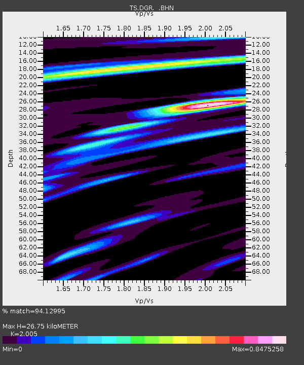
| Estimated Moho Depth: |
26.75 km |
| Estimated Crust Vp/Vs: |
2.01 |
| Assumed Crust Vp: |
6.264 km/s |
| Estimated Crust Vs: |
3.124 km/s |
| Estimated Crust Poisson's Ratio: |
0.33 |
|
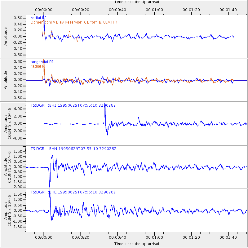
| Radial Match: |
94.12995 % |
| Radial Bump: |
383 |
| Transverse Match: |
83.8376 % |
| Transverse Bump: |
400 |
| SOD ConfigId: |
6273 |
| Insert Time: |
2010-02-26 14:08:09.318 +0000 |
| GWidth: |
2.5 |
| Max Bumps: |
400 |
| Tol: |
0.001 |
|
Signal To Noise
| Channel | StoN | STA | LTA |
| TS:DGR: :BHN:19950629T07:55:10.329028Z | 10.721408 | 7.274741E-7 | 6.785248E-8 |
| TS:DGR: :BHE:19950629T07:55:10.329028Z | 9.668137 | 6.270031E-7 | 6.485253E-8 |
| TS:DGR: :BHZ:19950629T07:55:10.329028Z | 21.58946 | 1.8246329E-6 | 8.451498E-8 |
| Arrivals |
| Ps | 4.4 SECOND |
| PpPs | 12 SECOND |
| PsPs/PpSs | 17 SECOND |


