You are here: Home > Network List > II - Global Seismograph Network (GSN - IRIS/IDA) Stations List
> Station WRAB Tennant Creek, NT, Australia > Earthquake Result Viewer
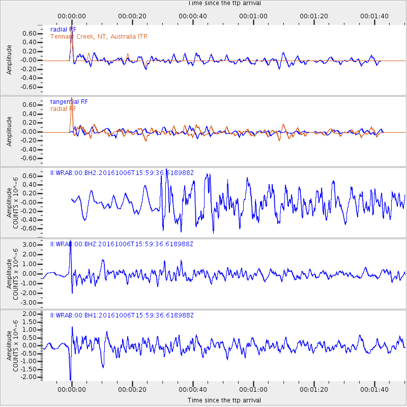
WRAB Tennant Creek, NT, Australia - Earthquake Result Viewer
*The percent match for this event was below the threshold and hence no stack was calculated.
| Earthquake location: |
Taiwan Region |
| Earthquake latitude/longitude: |
22.6/121.4 |
| Earthquake time(UTC): |
2016/10/06 (280) 15:52:00 GMT |
| Earthquake Depth: |
17 km |
| Earthquake Magnitude: |
5.7 MO |
| Earthquake Catalog/Contributor: |
NEIC PDE/NEIC ALERT |
|
| Network: |
II Global Seismograph Network (GSN - IRIS/IDA) |
| Station: |
WRAB Tennant Creek, NT, Australia |
| Lat/Lon: |
19.93 S/134.36 E |
| Elevation: |
366 m |
|
| Distance: |
44.1 deg |
| Az: |
162.42 deg |
| Baz: |
342.744 deg |
| Ray Param: |
$rayparam |
*The percent match for this event was below the threshold and hence was not used in the summary stack. |
|
| Radial Match: |
72.34142 % |
| Radial Bump: |
400 |
| Transverse Match: |
51.753933 % |
| Transverse Bump: |
400 |
| SOD ConfigId: |
1634031 |
| Insert Time: |
2016-10-20 15:54:05.978 +0000 |
| GWidth: |
2.5 |
| Max Bumps: |
400 |
| Tol: |
0.001 |
|
Signal To Noise
| Channel | StoN | STA | LTA |
| II:WRAB:00:BHZ:20161006T15:59:36.618988Z | 4.005464 | 1.0975629E-6 | 2.7401643E-7 |
| II:WRAB:00:BH1:20161006T15:59:36.618988Z | 4.95449 | 7.045334E-7 | 1.4220099E-7 |
| II:WRAB:00:BH2:20161006T15:59:36.618988Z | 2.3616085 | 3.846779E-7 | 1.6288809E-7 |
| Arrivals |
| Ps | |
| PpPs | |
| PsPs/PpSs | |


