You are here: Home > Network List > TA - USArray Transportable Network (new EarthScope stations) Stations List
> Station V25A Rancho No Tengo, Wagon Mound, NM, USA > Earthquake Result Viewer
V25A Rancho No Tengo, Wagon Mound, NM, USA - Earthquake Result Viewer
| Earthquake location: |
Virgin Islands |
| Earthquake latitude/longitude: |
19.2/-64.8 |
| Earthquake time(UTC): |
2008/10/11 (285) 10:40:14 GMT |
| Earthquake Depth: |
23 km |
| Earthquake Magnitude: |
6.1 MB, 5.9 MS, 6.1 MW, 6.0 MW |
| Earthquake Catalog/Contributor: |
WHDF/NEIC |
|
| Network: |
TA USArray Transportable Network (new EarthScope stations) |
| Station: |
V25A Rancho No Tengo, Wagon Mound, NM, USA |
| Lat/Lon: |
35.84 N/104.62 W |
| Elevation: |
1861 m |
|
| Distance: |
38.7 deg |
| Az: |
303.742 deg |
| Baz: |
104.67 deg |
| Ray Param: |
0.07537584 |
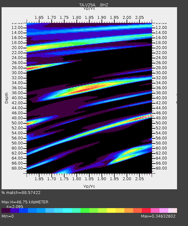
| Estimated Moho Depth: |
46.75 km |
| Estimated Crust Vp/Vs: |
2.10 |
| Assumed Crust Vp: |
6.419 km/s |
| Estimated Crust Vs: |
3.064 km/s |
| Estimated Crust Poisson's Ratio: |
0.35 |
|
| Radial Match: |
88.57422 % |
| Radial Bump: |
278 |
| Transverse Match: |
71.67232 % |
| Transverse Bump: |
400 |
| SOD ConfigId: |
2556 |
| Insert Time: |
2010-03-06 20:55:35.014 +0000 |
| GWidth: |
2.5 |
| Max Bumps: |
400 |
| Tol: |
0.001 |
|

Signal To Noise
| Channel | StoN | STA | LTA |
| TA:V25A: :BHZ:20081011T10:47:05.398989Z | 3.7526972 | 1.8306937E-6 | 4.878341E-7 |
| TA:V25A: :BHN:20081011T10:47:05.398989Z | 1.5781661 | 3.577369E-7 | 2.2667885E-7 |
| TA:V25A: :BHE:20081011T10:47:05.398989Z | 2.3035374 | 1.0170232E-6 | 4.4150497E-7 |
| Arrivals |
| Ps | 8.5 SECOND |
| PpPs | 21 SECOND |
| PsPs/PpSs | 30 SECOND |


