You are here: Home > Network List > TA - USArray Transportable Network (new EarthScope stations) Stations List
> Station E20K Nigu River, AK, USA > Earthquake Result Viewer
E20K Nigu River, AK, USA - Earthquake Result Viewer
*The percent match for this event was below the threshold and hence no stack was calculated.
| Earthquake location: |
Colombia |
| Earthquake latitude/longitude: |
4.6/-76.3 |
| Earthquake time(UTC): |
2019/03/23 (082) 19:21:16 GMT |
| Earthquake Depth: |
113 km |
| Earthquake Magnitude: |
6.1 Mww |
| Earthquake Catalog/Contributor: |
NEIC PDE/us |
|
| Network: |
TA USArray Transportable Network (new EarthScope stations) |
| Station: |
E20K Nigu River, AK, USA |
| Lat/Lon: |
68.26 N/156.19 W |
| Elevation: |
866 m |
|
| Distance: |
82.0 deg |
| Az: |
338.261 deg |
| Baz: |
97.699 deg |
| Ray Param: |
$rayparam |
*The percent match for this event was below the threshold and hence was not used in the summary stack. |
|
| Radial Match: |
68.747665 % |
| Radial Bump: |
400 |
| Transverse Match: |
61.806923 % |
| Transverse Bump: |
400 |
| SOD ConfigId: |
13570011 |
| Insert Time: |
2019-05-02 19:12:06.467 +0000 |
| GWidth: |
2.5 |
| Max Bumps: |
400 |
| Tol: |
0.001 |
|
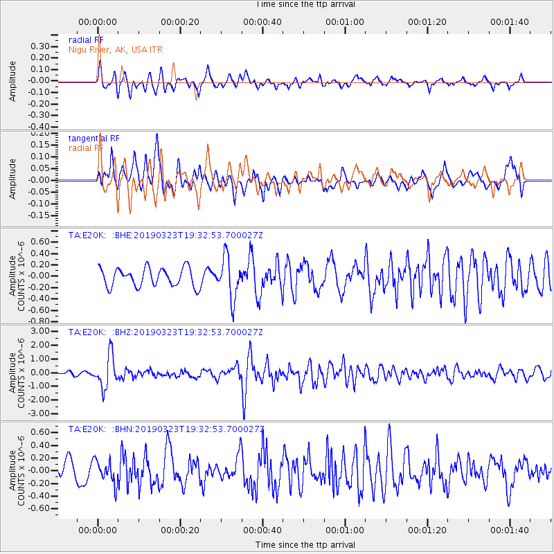
Signal To Noise
| Channel | StoN | STA | LTA |
| TA:E20K: :BHZ:20190323T19:32:53.700027Z | 8.131662 | 1.2114006E-6 | 1.4897329E-7 |
| TA:E20K: :BHN:20190323T19:32:53.700027Z | 1.1282622 | 1.8335486E-7 | 1.6251086E-7 |
| TA:E20K: :BHE:20190323T19:32:53.700027Z | 2.3140705 | 3.6984432E-7 | 1.5982414E-7 |
| Arrivals |
| Ps | |
| PpPs | |
| PsPs/PpSs | |


