You are here: Home > Network List > TA - USArray Transportable Network (new EarthScope stations) Stations List
> Station V25A Rancho No Tengo, Wagon Mound, NM, USA > Earthquake Result Viewer
V25A Rancho No Tengo, Wagon Mound, NM, USA - Earthquake Result Viewer
| Earthquake location: |
Tonga Islands |
| Earthquake latitude/longitude: |
-16.3/-173.5 |
| Earthquake time(UTC): |
2009/10/02 (275) 01:07:39 GMT |
| Earthquake Depth: |
8.0 km |
| Earthquake Magnitude: |
6.1 MB, 6.0 MS, 6.1 MW, 6.1 MW |
| Earthquake Catalog/Contributor: |
WHDF/NEIC |
|
| Network: |
TA USArray Transportable Network (new EarthScope stations) |
| Station: |
V25A Rancho No Tengo, Wagon Mound, NM, USA |
| Lat/Lon: |
35.84 N/104.62 W |
| Elevation: |
1861 m |
|
| Distance: |
83.2 deg |
| Az: |
49.747 deg |
| Baz: |
244.402 deg |
| Ray Param: |
0.046364762 |
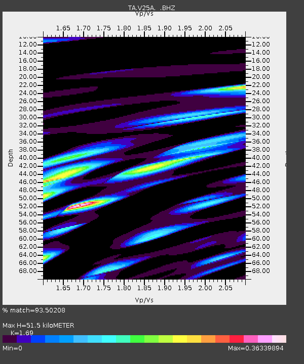
| Estimated Moho Depth: |
51.5 km |
| Estimated Crust Vp/Vs: |
1.69 |
| Assumed Crust Vp: |
6.419 km/s |
| Estimated Crust Vs: |
3.798 km/s |
| Estimated Crust Poisson's Ratio: |
0.23 |
|
| Radial Match: |
93.50208 % |
| Radial Bump: |
308 |
| Transverse Match: |
82.43097 % |
| Transverse Bump: |
400 |
| SOD ConfigId: |
2622 |
| Insert Time: |
2010-03-06 20:56:11.411 +0000 |
| GWidth: |
2.5 |
| Max Bumps: |
400 |
| Tol: |
0.001 |
|

Signal To Noise
| Channel | StoN | STA | LTA |
| TA:V25A: :BHZ:20091002T01:19:34.424001Z | 4.2656727 | 4.9020554E-7 | 1.14918706E-7 |
| TA:V25A: :BHN:20091002T01:19:34.424001Z | 3.326788 | 1.7952921E-7 | 5.396473E-8 |
| TA:V25A: :BHE:20091002T01:19:34.424001Z | 2.303891 | 2.0000302E-7 | 8.681098E-8 |
| Arrivals |
| Ps | 5.7 SECOND |
| PpPs | 21 SECOND |
| PsPs/PpSs | 27 SECOND |


