You are here: Home > Network List > TS - TERRAscope (Southern California Seismic Network) Stations List
> Station DGR Domenigoni Valley Reservior, California, USA > Earthquake Result Viewer
DGR Domenigoni Valley Reservior, California, USA - Earthquake Result Viewer
| Earthquake location: |
Tonga Islands |
| Earthquake latitude/longitude: |
-15.2/-173.6 |
| Earthquake time(UTC): |
1995/04/07 (097) 22:06:58 GMT |
| Earthquake Depth: |
31 km |
| Earthquake Magnitude: |
6.7 MB, 8.0 MS, 7.5 UNKNOWN, 7.1 MD |
| Earthquake Catalog/Contributor: |
WHDF/NEIC |
|
| Network: |
TS TERRAscope (Southern California Seismic Network) |
| Station: |
DGR Domenigoni Valley Reservior, California, USA |
| Lat/Lon: |
33.65 N/117.01 W |
| Elevation: |
700 m |
|
| Distance: |
72.5 deg |
| Az: |
46.876 deg |
| Baz: |
237.653 deg |
| Ray Param: |
0.053545583 |
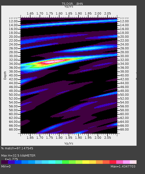
| Estimated Moho Depth: |
32.5 km |
| Estimated Crust Vp/Vs: |
1.77 |
| Assumed Crust Vp: |
6.264 km/s |
| Estimated Crust Vs: |
3.529 km/s |
| Estimated Crust Poisson's Ratio: |
0.27 |
|
| Radial Match: |
97.147545 % |
| Radial Bump: |
320 |
| Transverse Match: |
91.38747 % |
| Transverse Bump: |
400 |
| SOD ConfigId: |
6273 |
| Insert Time: |
2010-02-26 14:08:18.150 +0000 |
| GWidth: |
2.5 |
| Max Bumps: |
400 |
| Tol: |
0.001 |
|

Signal To Noise
| Channel | StoN | STA | LTA |
| TS:DGR: :BHN:19950407T22:17:50.979004Z | 5.875975 | 8.629196E-7 | 1.4685556E-7 |
| TS:DGR: :BHE:19950407T22:17:50.979004Z | 9.438581 | 1.5498972E-6 | 1.642087E-7 |
| TS:DGR: :BHZ:19950407T22:17:50.979004Z | 17.30722 | 4.5854995E-6 | 2.649472E-7 |
| Arrivals |
| Ps | 4.2 SECOND |
| PpPs | 14 SECOND |
| PsPs/PpSs | 18 SECOND |


